Sample Service Requests
This chapter provides various sample requests. Those requests are against a operational service but still might get obsolete over time. If that is the case, please let us know:
For more information about used authentication and authorization for the purposes of trying out the sample requests yourselves, please have a look at Authentication.
Web Client
The web and services are accessible on the production URL:
sso.<collection>.pass.copernicus.eu
Currently as of writing these collections/datasets are available:
Copernicus DEM Restricted https://sso.dem.pass.copernicus.eu
VHR1-2 Urban Atlas 2012 https://sso.ua2012.pass.copernicus.eu
DWH_MG2_CORE_01 - Optical HR Pan EU Coverages (Image2012) https://sso.core12.pass.copernicus.eu
Some publicly available deployments of View Server can be found on:
Some examples of available requests follow.
Performance optimized viewing
HTTP request: https://sso.vhr18.pass.copernicus.eu/cache/ows/wmts/1.0.0/WMTSCapabilities.xml
<?xml version="1.0" encoding="UTF-8"?>
<Capabilities version="1.0.0" xmlns="http://www.opengis.net/wmts/1.0" xmlns:gml="http://www.opengis.net/gml" xmlns:inspire_common="http://inspire.ec.europa.eu/schemas/common/1.0" xmlns:inspire_vs="http://inspire.ec.europa.eu/schemas/inspire_vs_ows11/1.0" xmlns:ows="http://www.opengis.net/ows/1.1" xmlns:xlink="http://www.w3.org/1999/xlink" xmlns:xsi="http://www.w3.org/2001/XMLSchema-instance" xsi:schemaLocation="http://www.opengis.net/wmts/1.0 http://schemas.opengis.net/wmts/1.0/wmtsGetCapabilities_response.xsd http://inspire.ec.europa.eu/schemas/inspire_vs_ows11/1.0 http://inspire.ec.europa.eu/schemas/inspire_vs_ows11/1.0/inspire_vs_ows_11.xsd">
  <ows:ServiceIdentification>
    <ows:Title>PRISM Data Access Service (PASS) developed by EOX</ows:Title>
    <ows:Abstract>PRISM Data Access Service (PASS) developed by EOX</ows:Abstract>
    <ows:Keywords>
      <ows:Keyword>view service</ows:Keyword>
    </ows:Keywords>
    <ows:ServiceType>OGC WMTS</ows:ServiceType>
    <ows:ServiceTypeVersion>1.0.0</ows:ServiceTypeVersion>
    <ows:Fees>UNKNOWN</ows:Fees>
    <ows:AccessConstraints>UNKNOWN</ows:AccessConstraints>
  </ows:ServiceIdentification>
  <ows:ServiceProvider>
    <stripped/>
  </ows:ServiceProvider>
  <ows:OperationsMetadata>
    <ows:Operation name="GetCapabilities">
      <ows:DCP>
        <ows:HTTP>
          <ows:Get xlink:href="https://sso.vhr18.pass.copernicus.eu/cache/ows/wmts?">
            <ows:Constraint name="GetEncoding">
              <ows:AllowedValues>
                <ows:Value>KVP</ows:Value>
              </ows:AllowedValues>
            </ows:Constraint>
          </ows:Get>
        </ows:HTTP>
      </ows:DCP>
    </ows:Operation>
    <ows:Operation name="GetTile">
      <ows:DCP>
        <ows:HTTP>
          <ows:Get xlink:href="https://sso.vhr18.pass.copernicus.eu/cache/ows/wmts?">
            <ows:Constraint name="GetEncoding">
              <ows:AllowedValues>
                <ows:Value>KVP</ows:Value>
              </ows:AllowedValues>
            </ows:Constraint>
          </ows:Get>
        </ows:HTTP>
      </ows:DCP>
    </ows:Operation>
    <ows:Operation name="GetFeatureInfo">
      <ows:DCP>
        <ows:HTTP>
          <ows:Get xlink:href="https://sso.vhr18.pass.copernicus.eu/cache/ows/wmts?">
            <ows:Constraint name="GetEncoding">
              <ows:AllowedValues>
                <ows:Value>KVP</ows:Value>
              </ows:AllowedValues>
            </ows:Constraint>
          </ows:Get>
        </ows:HTTP>
      </ows:DCP>
    </ows:Operation>
    <inspire_vs:ExtendedCapabilities>
      <inspire_common:MetadataUrl xsi:type="inspire_common:resourceLocatorType">
        <inspire_common:URL>TBD</inspire_common:URL>
        <inspire_common:MediaType>application/vnd.iso.19139+xml</inspire_common:MediaType>
      </inspire_common:MetadataUrl>
      <inspire_common:SupportedLanguages>
        <inspire_common:DefaultLanguage>
          <inspire_common:Language>eng</inspire_common:Language>
        </inspire_common:DefaultLanguage>
      </inspire_common:SupportedLanguages>
      <inspire_common:ResponseLanguage>
        <inspire_common:Language>eng</inspire_common:Language>
      </inspire_common:ResponseLanguage>
    </inspire_vs:ExtendedCapabilities>
  </ows:OperationsMetadata>
  <Contents>
    <Layer>
      <ows:Title>VHR Image 2018 Level 3 True Color with masked validity</ows:Title>
      <ows:Abstract>VHR Image 2018 Level 3 True Color with masked validity</ows:Abstract>
      <ows:WGS84BoundingBox>
        <ows:LowerCorner>-180.000000 -90.000000</ows:LowerCorner>
        <ows:UpperCorner>180.000000 90.000000</ows:UpperCorner>
      </ows:WGS84BoundingBox>
      <ows:Identifier>VHR_IMAGE_2018_Level_3__masked_validity</ows:Identifier>
      <Style isDefault="true">
        <ows:Identifier>default</ows:Identifier>
      </Style>
      <Format>image/unknown</Format>
      <Dimension>
        <ows:Identifier>time</ows:Identifier>
        <Default>2017/2019</Default>
        <Value>2017-05-01T09:54:28Z/2019-10-06T07:03:34Z</Value>
      </Dimension>
      <TileMatrixSetLink>
        <TileMatrixSet>WGS84</TileMatrixSet>
      </TileMatrixSetLink>
      <ResourceURL format="image/unknown" resourceType="tile" template="https://sso.vhr18.pass.copernicus.eu/cache/ows/wmts/1.0.0/VHR_IMAGE_2018_Level_3__masked_validity/default/{time}/{TileMatrixSet}/{TileMatrix}/{TileRow}/{TileCol}.xxx"/>
    </Layer>
    <Layer>
      <ows:Title>VHR Image 2018 Level 3 True Color with masked validity Full Coverage</ows:Title>
      <ows:Abstract>VHR Image 2018 Level 3 True Color with masked validity Full Coverage</ows:Abstract>
      <ows:WGS84BoundingBox>
        <ows:LowerCorner>-24.700000 27.500000</ows:LowerCorner>
        <ows:UpperCorner>45.000000 71.300000</ows:UpperCorner>
      </ows:WGS84BoundingBox>
      <ows:Identifier>VHR_IMAGE_2018_Level_3__masked_validity__Full</ows:Identifier>
      <Style isDefault="true">
        <ows:Identifier>default</ows:Identifier>
      </Style>
      <Format>image/unknown</Format>
      <TileMatrixSetLink>
        <TileMatrixSet>WGS84</TileMatrixSet>
      </TileMatrixSetLink>
      <ResourceURL format="image/unknown" resourceType="tile" template="https://sso.vhr18.pass.copernicus.eu/cache/ows/wmts/1.0.0/VHR_IMAGE_2018_Level_3__masked_validity__Full/default/{TileMatrixSet}/{TileMatrix}/{TileRow}/{TileCol}.xxx"/>
    </Layer>
    <stripped_12_layers/>
    <TileMatrixSet>
      <stripped/>
    </TileMatrixSet>
  </Contents>
</Capabilities>
HTTP request: https://sso.vhr18.pass.copernicus.eu/cache/ows?service=WMS&request=GetCapabilities
<?xml version="1.0" encoding="UTF-8" standalone="no" ?>
<!DOCTYPE WMT_MS_Capabilities
  SYSTEM 'http://schemas.opengis.net/wms/1.1.0/capabilities_1_1_0.dtd' [ <!ELEMENT VendorSpecificCapabilities EMPTY>]>
<WMT_MS_Capabilities version="1.1.1">
  <Service>
    <Name>OGC:WMS</Name>
    <Title>PRISM Data Access Service (PASS) developed by EOX</Title>
    <OnlineResource xlink:href="https://sso.vhr18.pass.copernicus.eu/cache/ows/?" xmlns:xlink="http://www.w3.org/1999/xlink"/>
  </Service>
  <Capability>
    <Request>
      <GetCapabilities>
        <Format>application/vnd.ogc.wms_xml</Format>
        <DCPType>
          <HTTP>
            <Get>
              <OnlineResource xlink:href="https://sso.vhr18.pass.copernicus.eu/cache/ows/?" xmlns:xlink="http://www.w3.org/1999/xlink"/>
            </Get>
          </HTTP>
        </DCPType>
      </GetCapabilities>
      <GetMap>
        <Format>image/png</Format>
        <Format>image/jpeg</Format>
        <DCPType>
          <HTTP>
            <Get>
              <OnlineResource xlink:href="https://sso.vhr18.pass.copernicus.eu/cache/ows/?" xmlns:xlink="http://www.w3.org/1999/xlink"/>
            </Get>
          </HTTP>
        </DCPType>
      </GetMap>
      <GetFeatureInfo>
        <Format>text/plain</Format>
        <Format>application/vnd.ogc.gml</Format>
        <DCPType>
          <HTTP>
            <Get>
              <OnlineResource xlink:href="https://sso.vhr18.pass.copernicus.eu/cache/ows/?" xmlns:xlink="http://www.w3.org/1999/xlink"/>
            </Get>
          </HTTP>
        </DCPType>
      </GetFeatureInfo>
    </Request>
    <Exception>
      <Format>text/plain</Format>
    </Exception>
    <VendorSpecificCapabilities>
      <stripped/>
    </VendorSpecificCapabilities>
    <Layer>
      <Title>PRISM Data Access Service (PASS) developed by EOX</Title>
      <SRS>EPSG:4326</SRS>
      <Layer cascaded="1" queryable="0">
        <Name>VHR_IMAGE_2018_Level_3__masked_validity</Name>
        <Title>VHR Image 2018 Level 3 True Color with masked validity</Title>
        <Abstract>VHR Image 2018 Level 3 True Color with masked validity</Abstract>
        <LatLonBoundingBox maxx="180.000000" maxy="90.000000" minx="-180.000000" miny="-90.000000"/>
        <Dimension default="2017/2019" name="time">2017-05-01T09:54:28Z/2019-10-06T07:03:34Z</Dimension>
        <BoundingBox SRS="EPSG:4326" maxx="180.000000" maxy="90.000000" minx="-180.000000" miny="-90.000000"/>
        <SRS>EPSG:4326</SRS>
      </Layer>
      <Layer cascaded="1" queryable="0">
        <Name>VHR_IMAGE_2018_Level_3__masked_validity__Full</Name>
        <Title>VHR Image 2018 Level 3 True Color with masked validity Full Coverage</Title>
        <Abstract>VHR Image 2018 Level 3 True Color with masked validity Full Coverage</Abstract>
        <LatLonBoundingBox maxx="45.000000" maxy="71.300000" minx="-24.700000" miny="27.500000"/>
        <BoundingBox SRS="EPSG:4326" maxx="45.000000" maxy="71.300000" minx="-24.700000" miny="27.500000"/>
        <SRS>EPSG:4326</SRS>
      </Layer>
      <stripped_12_layers/>
    </Layer>
  </Capability>
</WMT_MS_Capabilities>
HTTP request: https://sso.vhr18.pass.copernicus.eu/cache/ows/wmts/1.0.0/VHR_IMAGE_2018_Level_3__TRUE_COLOR/default/2018-06-01T00:00:00Z–2018-07-01T00:00:00Z/WGS84/11/524/2224.xxx
HTTP request: https://sso.vhr18.pass.copernicus.eu/cache/ows/wmts/1.0.0/VHR_IMAGE_2018_Level_3__FALSE_COLOR/default/2018-06-01T00:00:00Z–2018-07-01T00:00:00Z/WGS84/11/524/2224.xxx
HTTP request: https://sso.vhr18.pass.copernicus.eu/cache/ows/wmts/1.0.0/VHR_IMAGE_2018_Level_3__NDVI/default/2018-06-01T00:00:00Z–2018-07-01T00:00:00Z/WGS84/11/524/2224.xxx
Same area via WMS GetMap request.
HTTP request: https://sso.vhr18.pass.copernicus.eu/cache/ows?SERVICE=WMS&VERSION=1.1.0&REQUEST=GetMap&FORMAT=image/png&TRANSPARENT=true&LAYERS=VHR_IMAGE_2018_Level_3__TRUE_COLOR&STYLES=&time=2018-06-01T00:00:00Z/2018-07-01T00:00:00Z&WIDTH=256&HEIGHT=256&SRS=EPSG:4326&BBOX=15.46875,43.857421875,15.556640625,43.9453125
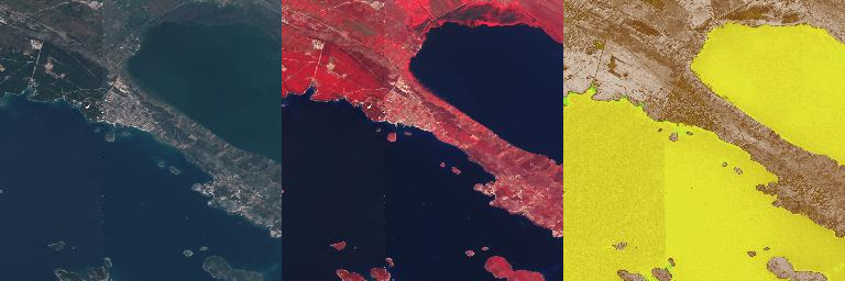
Figure 41 WMTS Tiles - True color, false color, and NDVI
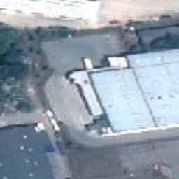
Figure 42 WMTS - Pansharpened
HTTP request: https://sso.vhr15.pass.copernicus.eu/cache/ows/wmts?layer=VHR_IMAGE_2015_Level_3__TRUE_COLOR_PANSHARPENED&style=default&tilematrixset=WGS84&Service=WMTS&Request=GetTile&Version=1.0.0&Format=image/png&TileMatrix=17&TileCol=140715&TileRow=27114&time=2015-07-03T10:27:50Z/2015-07-03T10:27:53Z
True Color non-pansharpened vhr15
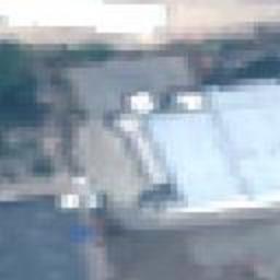
Figure 43 WMTS - Non-pansharpened
HTTP request: https://sso.vhr15.pass.copernicus.eu/cache/ows/wmts?layer=VHR_IMAGE_2015_Level_3__TRUE_COLOR&style=default&tilematrixset=WGS84&Service=WMTS&Request=GetTile&Version=1.0.0&Format=image/png&TileMatrix=17&TileCol=140715&TileRow=27114&time=2015-07-03T10:27:50Z/2015-07-03T10:27:53Z
True Color Percentile rendering 2-98% vhr15
Figure 44 WMTS - 2-98%
HTTP request: https://sso.vhr15.pass.copernicus.eu/cache/ows/wmts?layer=VHR_IMAGE_2015_Level_3__TRUE_COLOR_PERC&style=default&tilematrixset=WGS84&Service=WMTS&Request=GetTile&Version=1.0.0&Format=image/png&TileMatrix=15&TileCol=35178&TileRow=6778&time=2015-07-03T10:27:50Z/2015-07-03T10:27:53Z
True Color min/max statistics vhr15
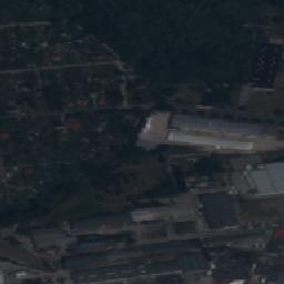
Figure 45 WMTS - min/max statistics
HTTP request: https://sso.vhr15.pass.copernicus.eu/cache/ows/wmts?layer=VHR_IMAGE_2015_Level_3__TRUE_COLOR_MIN_MAX&style=default&tilematrixset=WGS84&Service=WMTS&Request=GetTile&Version=1.0.0&Format=image/png&TileMatrix=15&TileCol=35178&TileRow=6778&time=2015-07-03T10:27:50Z/2015-07-03T10:27:53Z
True Color mean +- 1.5x standard deviation vhr15
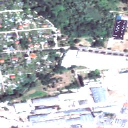
Figure 46 WMTS - mean +- 1.5x std
HTTP request: https://sso.vhr15.pass.copernicus.eu/cache/ows/wmts?layer=VHR_IMAGE_2015_Level_3__TRUE_COLOR_MEAN_STD_X&style=default&tilematrixset=WGS84&Service=WMTS&Request=GetTile&Version=1.0.0&Format=image/png&TileMatrix=15&TileCol=35178&TileRow=6778&time=2015-07-03T10:27:50Z/2015-07-03T10:27:53Z
WMTS True color masked validity tile
Figure 47 WMTS Tiles - Unmasked and masked
HTTP request: https://sso.vhr18.pass.copernicus.eu/cache/ows/wmts/1.0.0/VHR_IMAGE_2018_Level_3__masked_validity/default/2018-06-01T00:00:00Z–2018-07-01T00:00:00Z/WGS84/11/524/2224.xxx
Figure 48 WMTS Tiles - Full layer
HTTP request: https://sso.vhr18.pass.copernicus.eu/cache/ows/wmts/1.0.0/VHR_IMAGE_2018_Level_3__masked_validity__Full/default/WGS84/1/0/2.xxx
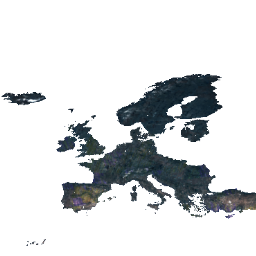
Figure 49 WMS - Full layer
HTTP request: https://sso.vhr18.pass.copernicus.eu/cache/ows?SERVICE=WMS&VERSION=1.1.0&REQUEST=GetMap&FORMAT=image/png&TRANSPARENT=true&LAYERS=VHR_IMAGE_2018_Level_3__masked_validity__Full&WIDTH=256&HEIGHT=256&SRS=EPSG:4326&BBOX=-25,25,40,90
Flexible viewing
WMS Capabilities for collection layers (example below)
HTTP request: https://sso.vhr18.pass.copernicus.eu/ows?service=wms&request=GetCapabilities
WMS Layer capabilities for one product
HTTP request: https://sso.vhr18.pass.copernicus.eu/ows?service=wms&request=GetCapabilities&cql=identifier=’urn:eop:DOVE:MULTISPECTRAL_4m:20180811_081455_1054_3be7’
<?xml version='1.0' encoding='iso-8859-1'?>
<WMS_Capabilities updateSequence="20131219T132000Z" version="1.3.0" xmlns="http://www.opengis.net/wms" xmlns:xlink="http://www.w3.org/1999/xlink" xmlns:xsi="http://www.w3.org/2001/XMLSchema-instance" xsi:schemaLocation="">
<Service>
<Name>PRISM Data Access Service (PASS) developed by EOX</Name>
<Title>PRISM Data Access Service (PASS) developed by EOX</Title>
<Abstract>PRISM Data Access Service (PASS) developed by EOX</Abstract>
<KeywordList>
<Keyword><KEYWORDLIST></Keyword>
</KeywordList>
<OnlineResource>http://eoxserver.org</OnlineResource>
<ContactInformation>
<ContactPersonPrimary>
<ContactPerson><CONTACTPERSON></ContactPerson>
<ContactOrganization><CONTACTORGANIZATION></ContactOrganization>
</ContactPersonPrimary>
<ContactPosition><CONTACTPOSITION></ContactPosition>
<ContactAddress>
<AddressType>postal</AddressType>
<Address><ADDRESS></Address>
<City><CITY></City>
<StateOrProvince><STATEORPROVINCE></StateOrProvince>
<PostCode><POSTCODE></PostCode>
<Country><COUNTRY></Country>
</ContactAddress>
<ContactVoiceTelephone><CONTACTVOICETELEPHONE></ContactVoiceTelephone>
<ContactFacsimileTelephone><CONTACTFACSIMILETELEPHONE></ContactFacsimileTelephone>
<ContactElectronicMailAddress><CONTACTELECTRONICMAILADDRESS></ContactElectronicMailAddress>
</ContactInformation>
<Fees>None</Fees>
<AccessConstraints>None</AccessConstraints>
</Service>
<Capability>
<Request>
<GetCapabilities>
<Format>text/xml</Format>
<DCPType>
<HTTP>
<Get>
<OnlineResource xlink:href="https://sso.vhr18.pass.copernicus.eu/ows" xlink:type="simple"/>
</Get>
</HTTP>
</DCPType>
</GetCapabilities>
<GetMap>
<Format>image/png</Format>
<Format>image/jpeg</Format>
<Format>image/gif</Format>
<Format>image/tiff</Format>
<DCPType>
<HTTP>
<Get>
<OnlineResource xlink:href="https://sso.vhr18.pass.copernicus.eu/ows" xlink:type="simple"/>
</Get>
</HTTP>
</DCPType>
</GetMap>
<GetFeatureInfo>
<Format/>
<DCPType>
<HTTP>
<Get>
<OnlineResource xlink:href="https://sso.vhr18.pass.copernicus.eu/ows" xlink:type="simple"/>
</Get>
</HTTP>
</DCPType>
</GetFeatureInfo>
</Request>
<Exception>
<Format>XML</Format>
<Format>INIMAGE</Format>
<Format>BLANK</Format>
</Exception>
<Layer>
<Title>PRISM Data Access Service (PASS) developed by EOX</Title>
<CRS>EPSG:4326</CRS>
<CRS>EPSG:3857</CRS>
<CRS>EPSG:3035</CRS>
<EX_GeographicBoundingBox>
<westBoundLongitude>-180</westBoundLongitude>
<eastBoundLongitude>180</eastBoundLongitude>
<southBoundLatitude>-90</southBoundLatitude>
<northBoundLatitude>90</northBoundLatitude>
</EX_GeographicBoundingBox>
<stripped_2_layer_groups/>
<Layer queryable="0">
<Name>VHR_IMAGE_2018_Level_3</Name>
<EX_GeographicBoundingBox>
<westBoundLongitude>-24.6397992939</westBoundLongitude>
<eastBoundLongitude>44.8308373419</eastBoundLongitude>
<southBoundLatitude>27.5748429858</southBoundLatitude>
<northBoundLatitude>71.2306420611</northBoundLatitude>
</EX_GeographicBoundingBox>
<Layer queryable="1">
<Name>VHR_IMAGE_2018_Level_3__outlines</Name>
<Style>
<Name>brown</Name>
<Abstract>brown</Abstract>
</Style>
<Style>
<Name>yellow</Name>
<Abstract>yellow</Abstract>
</Style>
<stripped_10_styles/>
</Layer>
<stripped_6_layers/>
<Layer queryable="0">
<Name>VHR_IMAGE_2018_Level_3__masked_validity</Name>
</Layer>
<Dimension default="2018-09-30T13:26:34Z" name="time" units="ISO8601">2017-05-01T09:54:28Z/2018-09-30T13:26:34Z/PT1S</Dimension>
</Layer>
</Layer>
</Capability>
</WMS_Capabilities>
Standard renderings
Figure 50 WMS - Quicklook
HTTP request: https://sso.vhr18.pass.copernicus.eu/ows?service=WMS&version=1.3.0&request=GetMap&layers=urn:eop:DOVE:MULTISPECTRAL_4m:20180811_081455_1054_3be7&format=image/png&TRANSPARENT=true&width=463&height=500&CRS=EPSG:4326&STYLES=&BBOX=47.297788,25.978201,47.372606,26.047511

Figure 51 WMS - False color
HTTP request: https://sso.vhr18.pass.copernicus.eu/ows?service=WMS&version=1.3.0&request=GetMap&layers=urn:eop:DOVE:MULTISPECTRAL_4m:20180811_081455_1054_3be7__FALSE_COLOR&format=image/png&TRANSPARENT=true&width=463&height=500&CRS=EPSG:4326&STYLES=&BBOX=47.297788,25.978201,47.372606,26.047511
Figure 52 WMS - NDVI custom style
HTTP request: https://sso.vhr18.pass.copernicus.eu/ows?service=WMS&version=1.3.0&request=GetMap&layers=urn:eop:DOVE:MULTISPECTRAL_4m:20180811_081455_1054_3be7__NDVI&format=image/png&TRANSPARENT=true&width=463&height=500&CRS=EPSG:4326&STYLES=coolwarm&BBOX=47.297788,25.978201,47.372606,26.047511
Custom color stretch as dim_range parameter
Figure 53 WMS - Custom color stretch
HTTP request: https://sso.vhr18.pass.copernicus.eu/ows?service=WMS&version=1.3.0&request=GetMap&layers=urn:eop:DOVE:MULTISPECTRAL_4m:20180811_081455_1054_3be7&format=image/png&TRANSPARENT=true&width=463&height=500&CRS=EPSG:4326&STYLES=&BBOX=47.297788,25.978201,47.372606,26.047511&dim_range=1000 5000
Custom band selection as RGB and color stretch as False color rendering

Figure 54 WMS - Custom bands
HTTP request: https://sso.vhr18.pass.copernicus.eu/ows?service=WMS&version=1.3.0&request=GetMap&layers=urn:eop:DOVE:MULTISPECTRAL_4m:20180811_081455_1054_3be7&format=image/png&TRANSPARENT=true&width=463&height=500&CRS=EPSG:4326&STYLES=&BBOX=47.297788,25.978201,47.372606,26.047511&dim_bands=nir,red,green&dim_range=1000 10000,1000 10000,1000 10000
CQL filtering on Cloud Coverage
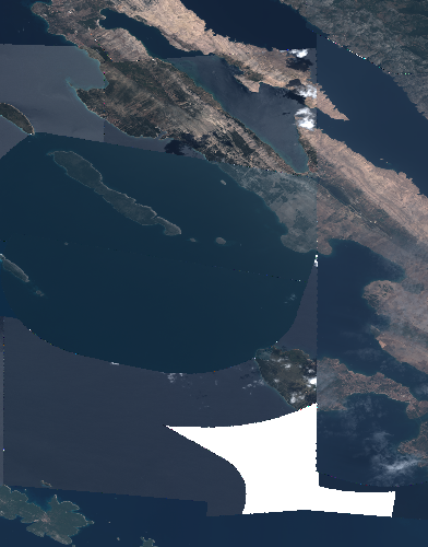
Figure 55 WMS - CQL filtering
HTTP request: https://sso.vhr18.pass.copernicus.eu/ows?service=WMS&version=1.3.0&request=GetMap&layers=VHR_IMAGE_2018_Level_3&format=image/png&TRANSPARENT=true&width=392&height=500&CRS=EPSG:4326&STYLES=&BBOX=44.196369,14.849791,44.554918,15.131223&cql=cloudCover<1

Figure 56 WMS - Clouds mask
HTTP request: https://sso.vhr18.pass.copernicus.eu/ows?SERVICE=WMS&VERSION=1.1.0&REQUEST=GetMap&FORMAT=image/png&TRANSPARENT=true&LAYERS=VHR_IMAGE_2018_Level_3__validity&STYLES=&time=2017-04-14T13:49:45Z/2018-09-05T00:00:00Z&WIDTH=256&HEIGHT=256&SRS=EPSG:4326&BBOX=15.78727912902832,43.005756378173835,16.976377487182617,44.05855560302735
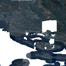
Figure 57 WMS - Masked clouds
HTTP request: https://sso.vhr18.pass.copernicus.eu/ows?SERVICE=WMS&VERSION=1.1.0&REQUEST=GetMap&FORMAT=image/png&TRANSPARENT=true&LAYERS=VHR_IMAGE_2018_Level_3__masked_validity&STYLES=&time=2017-04-14T13:49:45Z/2018-09-05T00:00:00Z&WIDTH=256&HEIGHT=256&SRS=EPSG:4326&BBOX=15.78727912902832,43.005756378173835,16.976377487182617,44.05855560302735
DEM collections
DEM collections allow to specify rendering variables via vendor WMS parameter VARIABLES.
Following list summarizes offered renderings for DEM data together with keys and default values, passable into VARIABLES parameter and default dim_range (color stretch) parameter applied.
elevation (standard DEM elevation rendering), no VARIABLES options. Can be used together with dim_range, STYLE, Default dim_range=-10 4000.
Sample elevation rendering with EARTH style
HTTP request: https://sso.demf.pass.copernicus.eu/ows?SERVICE=WMS&VERSION=1.1.0&REQUEST=GetMap&FORMAT=image/png&TRANSPARENT=true&LAYERS=urn:eop:DLR:CDEM30:Copernicus_DSM_10_N44_00_E015_00:VmZNr-2019_2__elevation&WIDTH=1034&HEIGHT=866&SRS=EPSG:4326&BBOX=15.123857649791466,44.200011640532416,15.75487079395557,44.728500405373914&STYLES=earth&DIM_RANGE=0 2000
contours, VARIABLES=offset=0,interval=30. Default dim_range=0 360. Meaning of variables: interval, offset.
HTTP request: https://sso.demf.pass.copernicus.eu/ows?SERVICE=WMS&VERSION=1.1.0&REQUEST=GetMap&FORMAT=image/png&TRANSPARENT=true&WIDTH=1034&HEIGHT=866&SRS=EPSG:4326&BBOX=15.123857649791466,44.200011640532416,15.75487079395557,44.728500405373914&LAYERS=urn:eop:DLR:CDEM30:Copernicus_DSM_10_N44_00_E015_00:VmZNr-2019_2__contours&DIM_RANGE=0 2000&VARIABLES=offset=0,interval=50
aspect, VARIABLES=alg=Horn. Default dim_range=0 360. Meaning of variable: alg.
HTTP request: https://sso.demf.pass.copernicus.eu/ows?SERVICE=WMS&VERSION=1.1.0&REQUEST=GetMap&FORMAT=image/png&TRANSPARENT=true&WIDTH=1034&HEIGHT=866&SRS=EPSG:4326&BBOX=15.123857649791466,44.200011640532416,15.75487079395557,44.728500405373914&LAYERS=urn:eop:DLR:CDEM30:Copernicus_DSM_10_N44_00_E015_00:VmZNr-2019_2__aspect&VARIABLES=alg=ZevenbergenThorne
hillshade, VARIABLES=zfactor=5,azimuth=315,altitude=45,alg=Horn. Default dim_range=0 255. Meaning of variables: alg, azimuth, altitude.
HTTP request: https://sso.demf.pass.copernicus.eu/ows?SERVICE=WMS&VERSION=1.1.0&REQUEST=GetMap&FORMAT=image/png&TRANSPARENT=true&WIDTH=1034&HEIGHT=866&SRS=EPSG:4326&BBOX=15.123857649791466,44.200011640532416,15.75487079395557,44.728500405373914&LAYERS=urn:eop:DLR:CDEM30:Copernicus_DSM_10_N44_00_E015_00:VmZNr-2019_2__hillshade&VARIABLES=zfactor=3,azimuth=45,altitude=60,alg=ZevenbergenThorne
slope, VARIABLES=alg=Horn, Default dim_range 0 50.
HTTP request: https://sso.demf.pass.copernicus.eu/ows?SERVICE=WMS&VERSION=1.1.0&REQUEST=GetMap&FORMAT=image/png&TRANSPARENT=true&WIDTH=1034&HEIGHT=866&SRS=EPSG:4326&BBOX=15.123857649791466,44.200011640532416,15.75487079395557,44.728500405373914&LAYERS=urn:eop:DLR:CDEM30:Copernicus_DSM_10_N44_00_E015_00:VmZNr-2019_2__slope&VARIABLES=alg=ZevenbergenThorne
roughness, no VARIABLES, Default dim_range=0 20.
Sample roughness map rendering
HTTP request: https://sso.demf.pass.copernicus.eu/ows?SERVICE=WMS&VERSION=1.1.0&REQUEST=GetMap&FORMAT=image/png&TRANSPARENT=true&WIDTH=1034&HEIGHT=866&SRS=EPSG:4326&BBOX=15.123857649791466,44.200011640532416,15.75487079395557,44.728500405373914&LAYERS=urn:eop:DLR:CDEM30:Copernicus_DSM_10_N44_00_E015_00:VmZNr-2019_2__roughness
tri, no VARIABLES, Default dim_range=0 8.
Sample Terrain Ruggedness Index (TRI) rendering
HTTP request: https://sso.demf.pass.copernicus.eu/ows?SERVICE=WMS&VERSION=1.1.0&REQUEST=GetMap&FORMAT=image/png&TRANSPARENT=true&WIDTH=1034&HEIGHT=866&SRS=EPSG:4326&BBOX=15.123857649791466,44.200011640532416,15.75487079395557,44.728500405373914&LAYERS=urn:eop:DLR:CDEM30:Copernicus_DSM_10_N44_00_E015_00:VmZNr-2019_2__tri
Statistics based rendering
Another set of collections, like VHR_IMAGE_2021 support statistics based rendering using per-product computed band statistics. By utilizing WMS parameter VARIABLES on WMS service, users are able to specify parameters of the percentile based rendering, flattening the color imbalance of products from same product type.
Following list lists some of such renderings for VHR_IMAGE_2021 data together with keys and default values, passable into VARIABLES parameter.
TRUE_COLOR - standard True color for comparison, no VARIABLES options.
Figure 58 WMS - vhr21 GeoEye true color
HTTP request: https://sso.vhr21.pass.copernicus.eu/ows?service=WMS&version=1.3.0&request=GetMap&layers=urn:eop:GEOEYE:MULTISPECTRAL_2m:105005002FDE8F00_projected_7531__TRUE_COLOR&format=image/png&TRANSPARENT=true&width=250&height=230&CRS=EPSG:4326&STYLES=&BBOX=52.625954,9.738781,52.848389,9.973384
TRUE_COLOR_PERC - Color stretch percentile based, VARIABLES=percmin=2,percmax=98.
Meaning of variables:
percmin: percentile value used as minimum for stretch
percmax: percentile value used as maximum for stretch
VHR21 True Color 3-97% Percentile
Figure 59 WMS - vhr21 GeoEye 3-97% percentile rendering
HTTP request: https://sso.vhr21.pass.copernicus.eu/ows?service=WMS&version=1.3.0&request=GetMap&layers=urn:eop:GEOEYE:MULTISPECTRAL_2m:105005002FDE8F00_projected_7531__TRUE_COLOR_PERC&format=image/png&TRANSPARENT=true&width=250&height=234&CRS=EPSG:4326&STYLES=&BBOX=52.625954,9.738781,52.848389,9.973384&VARIABLES=percmin=3,permax=97
TRUE_COLOR_MIN_MAX - Min max statistics stretch, no VARIABLES options
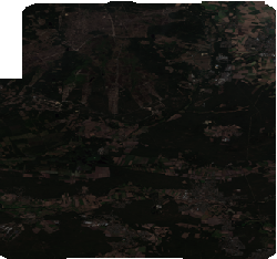
Figure 60 WMS - vhr21 GeoEye min/max
HTTP request: https://sso.vhr21.pass.copernicus.eu/ows?service=WMS&version=1.3.0&request=GetMap&layers=urn:eop:GEOEYE:MULTISPECTRAL_2m:105005002FDE8F00_projected_7531__TRUE_COLOR_MIN_MAX&format=image/png&TRANSPARENT=true&width=250&height=234&CRS=EPSG:4326&STYLES=&BBOX=52.625954,9.738781,52.848389,9.973384
TRUE_COLOR_MEAN_STD_X - Color stretch defined as Mean +- coefficient*std, VARIABLES=std_mult=2.
Meaning of variables:
std_mult: coefficient of multiplication of the std
VHR21 True Color mean +- 1.5x standard deviation
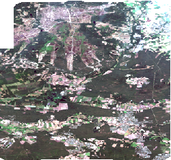
Figure 61 WMS - vhr21 GeoEye Mean +- 1.5x standard deviation
HTTP request: https://sso.vhr21.pass.copernicus.eu/ows?service=WMS&version=1.3.0&request=GetMap&layers=urn:eop:GEOEYE:MULTISPECTRAL_2m:105005002FDE8F00_projected_7531__TRUE_COLOR_MEAN_STD_X&format=image/png&TRANSPARENT=true&width=250&height=234&CRS=EPSG:4326&STYLES=&BBOX=52.625954,9.738781,52.848389,9.973384&VARIABLES=std_mult=1.5
Searching
1st step OSDD (stripped to only contain the Atom URL template)
HTTP request: https://sso.vhr18.pass.copernicus.eu/opensearch
<?xml version='1.0' encoding='iso-8859-1'?>
<OpenSearchDescription xmlns="http://a9.com/-/spec/opensearch/1.1/" xmlns:atom="http://www.w3.org/2005/Atom" xmlns:cql="http://a9.com/-/opensearch/extensions/cql/1.0/" xmlns:eo="http://a9.com/-/opensearch/extensions/eo/1.0/" xmlns:geo="http://a9.com/-/opensearch/extensions/geo/1.0/" xmlns:parameters="http://a9.com/-/spec/opensearch/extensions/parameters/1.0/" xmlns:time="http://a9.com/-/opensearch/extensions/time/1.0/" xmlns:xsi="http://www.w3.org/2001/XMLSchema-instance" xsi:schemaLocation="">
<ShortName/>
<Description/>
<Url indexOffset="0" parameters:enctype="application/x-www-form-urlencoded" parameters:method="GET" rel="collection" template="https://sso.vhr18.pass.copernicus.eu/opensearch/atom/?q={searchTerms?}&count={count?}&startIndex={startIndex?}&collection={eo:collection?}&productType={eo:productType?}&doi={eo:doi?}&platform={eo:platform?}&platformSerialIdentifier={eo:platformSerialIdentifier?}&instrument={eo:instrument?}&sensorType={eo:sensorType?}&compositeType={eo:compositeType?}&processingLevel={eo:processingLevel?}&orbitType={eo:orbitType?}&spectralRange={eo:spectralRange?}&wavelength={eo:wavelength?}&productMetadataSummary={eo:productMetadataSummary?}&coverageMetadataSummary={eo:coverageMetadataSummary?}&bbox={geo:box?}&geom={geo:geometry?}&lon={geo:lon?}&lat={geo:lat?}&r={geo:radius?}&georel={geo:relation?}&uid={geo:uid?}&start={time:start?}&end={time:end?}&timerel={time:relation?}&cql={cql:cql?}" type="application/atom+xml">
<parameters:Parameter maximum="1" minimum="0" name="q" value="{searchTerms}"/>
<parameters:Parameter maxInclusive="200" maximum="1" minInclusive="0" minimum="0" name="count" value="{count}"/>
<parameters:Parameter maximum="1" minInclusive="0" minimum="0" name="startIndex" value="{startIndex}"/>
<parameters:Parameter maximum="1" minimum="0" name="collection" value="{eo:collection}"/>
<parameters:Parameter maximum="1" minimum="0" name="productType" value="{eo:productType}"/>
<parameters:Parameter maximum="1" minimum="0" name="doi" value="{eo:doi}"/>
<parameters:Parameter maximum="1" minimum="0" name="platform" value="{eo:platform}"/>
<parameters:Parameter maximum="1" minimum="0" name="platformSerialIdentifier" value="{eo:platformSerialIdentifier}"/>
<parameters:Parameter maximum="1" minimum="0" name="instrument" value="{eo:instrument}"/>
<parameters:Parameter maximum="1" minimum="0" name="sensorType" value="{eo:sensorType}"/>
<parameters:Parameter maximum="1" minimum="0" name="compositeType" value="{eo:compositeType}"/>
<parameters:Parameter maximum="1" minimum="0" name="processingLevel" value="{eo:processingLevel}"/>
<parameters:Parameter maximum="1" minimum="0" name="orbitType" value="{eo:orbitType}"/>
<parameters:Parameter maximum="1" minimum="0" name="spectralRange" value="{eo:spectralRange}"/>
<parameters:Parameter maximum="1" minimum="0" name="wavelength" value="{eo:wavelength}"/>
<parameters:Parameter maximum="1" minimum="0" name="productMetadataSummary" value="{eo:productMetadataSummary}"/>
<parameters:Parameter maximum="1" minimum="0" name="coverageMetadataSummary" value="{eo:coverageMetadataSummary}"/>
<parameters:Parameter maximum="1" minimum="0" name="bbox" value="{geo:box}"/>
<parameters:Parameter maximum="1" minimum="0" name="geom" value="{geo:geometry}">
<atom:link href="http://www.opengis.net/wkt/LINESTRING" rel="profile" title="This service accepts WKT LineStrings"/>
<atom:link href="http://www.opengis.net/wkt/POINT" rel="profile" title="This service accepts WKT Point"/>
<atom:link href="http://www.opengis.net/wkt/POLYGON" rel="profile" title="This service accepts WKT Polygons"/>
<atom:link href="http://www.opengis.net/wkt/MULTILINESTRING" rel="profile" title="This service accepts WKT Multi-LineStrings"/>
<atom:link href="http://www.opengis.net/wkt/MULTIPOINT" rel="profile" title="This service accepts WKT Multi-Point"/>
<atom:link href="http://www.opengis.net/wkt/MULTIPOLYGON" rel="profile" title="This service accepts WKT Multi-Polygons"/>
</parameters:Parameter>
<parameters:Parameter maximum="1" minimum="0" name="lon" value="{geo:lon}"/>
<parameters:Parameter maximum="1" minimum="0" name="lat" value="{geo:lat}"/>
<parameters:Parameter maximum="1" minimum="0" name="r" value="{geo:radius}"/>
<parameters:Parameter maximum="1" minimum="0" name="georel" value="{geo:relation}">
<parameters:Option label="intersects" value="intersects"/>
<parameters:Option label="contains" value="contains"/>
<parameters:Option label="disjoint" value="disjoint"/>
</parameters:Parameter>
<parameters:Parameter maximum="1" minimum="0" name="uid" value="{geo:uid}"/>
<parameters:Parameter maximum="1" minimum="0" name="start" value="{time:start}"/>
<parameters:Parameter maximum="1" minimum="0" name="end" value="{time:end}"/>
<parameters:Parameter maximum="1" minimum="0" name="timerel" value="{time:relation}">
<parameters:Option label="intersects" value="intersects"/>
<parameters:Option label="contains" value="contains"/>
<parameters:Option label="disjoint" value="disjoint"/>
<parameters:Option label="equals" value="equals"/>
</parameters:Parameter>
<parameters:Parameter maximum="1" minimum="0" name="cql" value="{cql:cql}">
<atom:link href="http://www.opengis.net/csw/3.0/cql" rel="profile" title="CQL (Common Query Language) is a query language created by the OGC for the Catalogue Web Services specification."/>
</parameters:Parameter>
</Url>
<stripped/>
</OpenSearchDescription>
1st step search for collections
HTTP request: https://sso.vhr18.pass.copernicus.eu/opensearch/atom/
<feed xmlns="http://www.w3.org/2005/Atom" xmlns:cql="http://a9.com/-/opensearch/extensions/cql/1.0/" xmlns:dc="http://purl.org/dc/elements/1.1/" xmlns:eo="http://a9.com/-/opensearch/extensions/eo/1.0/" xmlns:geo="http://a9.com/-/opensearch/extensions/geo/1.0/" xmlns:georss="http://www.georss.org/georss" xmlns:media="http://search.yahoo.com/mrss/" xmlns:opensearch="http://a9.com/-/spec/opensearch/1.1/" xmlns:owc="http://www.opengis.net/owc/1.0" xmlns:time="http://a9.com/-/opensearch/extensions/time/1.0/">
<id>https://sso.vhr18.pass.copernicus.eu/opensearch/atom/</id>
<title>None Search</title>
<description/>
<opensearch:totalResults>3</opensearch:totalResults>
<opensearch:startIndex>0</opensearch:startIndex>
<opensearch:itemsPerPage>3</opensearch:itemsPerPage>
<opensearch:Query role="request"/>
<link href="https://sso.vhr18.pass.copernicus.eu/opensearch/" rel="search" type="application/opensearchdescription+xml"/>
<link href="https://sso.vhr18.pass.copernicus.eu/opensearch/atom/" rel="self" type="application/atom+xml"/>
<link href="https://sso.vhr18.pass.copernicus.eu/opensearch/atom/?" rel="first" type="application/atom+xml"/>
<link href="https://sso.vhr18.pass.copernicus.eu/opensearch/atom/?startIndex=0" rel="last" type="application/atom+xml"/>
<entry>
<title>VHR_IMAGE_2018_Level_3</title>
<id>https://sso.vhr18.pass.copernicus.eu/opensearch/atom/?uid=VHR_IMAGE_2018_Level_3</id>
<dc:identifier>VHR_IMAGE_2018_Level_3</dc:identifier>
<dc:date>2017-05-01T09:54:28Z/2018-09-30T13:26:34Z</dc:date>
<georss:box>27.574843 -24.639799 71.230642 44.830837</georss:box>
<georss:where>
<gml:MultiSurface gml:id="multisurface_VHR_IMAGE_2018_Level_3" srsName="EPSG:4326" xmlns:eop="http://www.opengis.net/eop/2.0" xmlns:gml="http://www.opengis.net/gml/3.2" xmlns:gmlcov="http://www.opengis.net/gmlcov/1.0" xmlns:om="http://www.opengis.net/om/2.0">
<gml:surfaceMember>
<gml:Polygon gml:id="polygon_VHR_IMAGE_2018_Level_3">
<gml:exterior>
<gml:LinearRing>
<gml:posList>27.57484299 -24.63979929 71.23064206 -24.63979929 71.23064206 44.83083734 27.57484299 44.83083734 27.57484299 -24.63979929</gml:posList>
</gml:LinearRing>
</gml:exterior>
</gml:Polygon>
</gml:surfaceMember>
</gml:MultiSurface>
</georss:where>
<link href="https://sso.vhr18.pass.copernicus.eu/opensearch/collections/VHR_IMAGE_2018_Level_3/" rel="search" type="application/opensearchdescription+xml"/>
<summary type="html">
<![CDATA[<table><tr><td valign="top" width="10%"><a href="https://sso.vhr18.pass.copernicus.eu/ows?service=WMS&version=1.3.0&request=GetMap&layers=VHR_IMAGE_2018_Level_3&format=image/png&TRANSPARENT=true&width=500&height=314&CRS=EPSG:4326&STYLES=&BBOX=27.574843,-24.639799,71.230642,44.830837" target="_blank" title="View quicklook image"><img align="left" border="0" hspace="8" src="https://sso.vhr18.pass.copernicus.eu/ows?service=WMS&version=1.3.0&request=GetMap&layers=VHR_IMAGE_2018_Level_3&format=image/png&TRANSPARENT=true&width=100&height=62&CRS=EPSG:4326&STYLES=&BBOX=27.574843,-24.639799,71.230642,44.830837" /></a></td><td valign="top" width="90%"><table><tr valign="top"><td><b>Date </b></td><td>2017-05-01T09:54:28+00:00 / 2018-09-30T13:26:34+00:00</td></tr><tr valign="top"><td><b>Metadata</b></td><td><a href="https://sso.vhr18.pass.copernicus.eu/opensearch/atom/?uid=VHR_IMAGE_2018_Level_3" title="Atom format" target="_blank">ATOM</a></td></tr></table></td></tr></table><h3>OGC cross links</h3><ul><li><b>WMS</b><ul><li><a href="https://sso.vhr18.pass.copernicus.eu/ows?service=WMS&request=GetCapabilities&cql=identifier='VHR_IMAGE_2018_Level_3'" target="_blank">GetCapabilities</a></li></ul><ul><li><a href="https://sso.vhr18.pass.copernicus.eu/ows?service=WMS&version=1.3.0&request=GetMap&layers=VHR_IMAGE_2018_Level_3&format=image/png&TRANSPARENT=true&width=500&height=314&CRS=EPSG:4326&STYLES=&BBOX=27.574843,-24.639799,71.230642,44.830837" target="_blank">GetMap</a></li></ul></li><li><b>WCS</b><ul><li><a href="https://sso.vhr18.pass.copernicus.eu/ows?service=WCS&version=2.0.1&request=DescribeEOCoverageSet&eoId=VHR_IMAGE_2018_Level_3" target="_blank">DescribeEOCoverageSet</a></li></ul></li></ul><h3>Metadata</h3><table></table>]]>
</summary>
</entry>
</feed>
2nd step OSDD (stripped to only contain the Atom URL template)
HTTP request: https://sso.vhr18.pass.copernicus.eu/opensearch/collections/VHR_IMAGE_2018_Level_3/
<?xml version='1.0' encoding='iso-8859-1'?>
<OpenSearchDescription xmlns="http://a9.com/-/spec/opensearch/1.1/" xmlns:atom="http://www.w3.org/2005/Atom" xmlns:cql="http://a9.com/-/opensearch/extensions/cql/1.0/" xmlns:eo="http://a9.com/-/opensearch/extensions/eo/1.0/" xmlns:geo="http://a9.com/-/opensearch/extensions/geo/1.0/" xmlns:parameters="http://a9.com/-/spec/opensearch/extensions/parameters/1.0/" xmlns:time="http://a9.com/-/opensearch/extensions/time/1.0/" xmlns:xsi="http://www.w3.org/2001/XMLSchema-instance" xsi:schemaLocation="">
<ShortName>VHR_IMAGE_2018_Level_3</ShortName>
<Description/>
<Url indexOffset="0" parameters:enctype="application/x-www-form-urlencoded" parameters:method="GET" rel="results" template="https://sso.vhr18.pass.copernicus.eu/opensearch/collections/VHR_IMAGE_2018_Level_3/atom/?q={searchTerms?}&count={count?}&startIndex={startIndex?}&product={eo:product?}&parentIdentifier={eo:parentIdentifier?}&productionStatus={eo:productionStatus?}&acquisitionType={eo:acquisitionType?}&orbitNumber={eo:orbitNumber?}&orbitDirection={eo:orbitDirection?}&track={eo:track?}&frame={eo:frame?}&swathIdentifier={eo:swathIdentifier?}&productVersion={eo:productVersion?}&productQualityStatus={eo:productQualityStatus?}&productQualityDegradationTag={eo:productQualityDegradationTag?}&processorName={eo:processorName?}&processingCenter={eo:processingCenter?}&creationDate={eo:creationDate?}&modificationDate={eo:modificationDate?}&processingDate={eo:processingDate?}&sensorMode={eo:sensorMode?}&archivingCenter={eo:archivingCenter?}&processingMode={eo:processingMode?}&availabilityTime={eo:availabilityTime?}&acquisitionStation={eo:acquisitionStation?}&acquisitionSubType={eo:acquisitionSubType?}&startTimeFromAscendingNode={eo:startTimeFromAscendingNode?}&completionTimeFromAscendingNode={eo:completionTimeFromAscendingNode?}&illuminationAzimuthAngle={eo:illuminationAzimuthAngle?}&illuminationZenithAngle={eo:illuminationZenithAngle?}&illuminationElevationAngle={eo:illuminationElevationAngle?}&polarisationMode={eo:polarisationMode?}&polarizationChannels={eo:polarizationChannels?}&antennaLookDirection={eo:antennaLookDirection?}&minimumIncidenceAngle={eo:minimumIncidenceAngle?}&maximumIncidenceAngle={eo:maximumIncidenceAngle?}&dopplerFrequency={eo:dopplerFrequency?}&incidenceAngleVariation={eo:incidenceAngleVariation?}&cloudCover={eo:cloudCover?}&snowCover={eo:snowCover?}&lowestLocation={eo:lowestLocation?}&highestLocation={eo:highestLocation?}&bbox={geo:box?}&geom={geo:geometry?}&lon={geo:lon?}&lat={geo:lat?}&r={geo:radius?}&georel={geo:relation?}&uid={geo:uid?}&start={time:start?}&end={time:end?}&timerel={time:relation?}&cql={cql:cql?}" type="application/atom+xml">
<parameters:Parameter maximum="1" minimum="0" name="q" value="{searchTerms}"/>
<parameters:Parameter maxInclusive="200" maximum="1" minInclusive="0" minimum="0" name="count" value="{count}"/>
<parameters:Parameter maximum="1" minInclusive="0" minimum="0" name="startIndex" value="{startIndex}"/>
<parameters:Parameter maximum="1" minimum="0" name="product" value="{eo:product}"/>
<parameters:Parameter maximum="1" minimum="0" name="parentIdentifier" value="{eo:parentIdentifier}"/>
<parameters:Parameter maximum="1" minimum="0" name="productionStatus" value="{eo:productionStatus}">
<parameters:Option label="ACQUIRED" value="ACQUIRED"/>
<parameters:Option label="CANCELLED" value="CANCELLED"/>
<parameters:Option label="ARCHIVED" value="ARCHIVED"/>
</parameters:Parameter>
<parameters:Parameter maximum="1" minimum="0" name="acquisitionType" value="{eo:acquisitionType}">
<parameters:Option label="NOMINAL" value="NOMINAL"/>
<parameters:Option label="OTHER" value="OTHER"/>
<parameters:Option label="CALIBRATION" value="CALIBRATION"/>
</parameters:Parameter>
<parameters:Parameter maximum="1" minimum="0" name="orbitNumber" value="{eo:orbitNumber}"/>
<parameters:Parameter maximum="1" minimum="0" name="orbitDirection" value="{eo:orbitDirection}">
<parameters:Option label="DESCENDING" value="DESCENDING"/>
<parameters:Option label="ASCENDING" value="ASCENDING"/>
</parameters:Parameter>
<parameters:Parameter maximum="1" minimum="0" name="track" value="{eo:track}"/>
<parameters:Parameter maximum="1" minimum="0" name="frame" value="{eo:frame}"/>
<parameters:Parameter maximum="1" minimum="0" name="swathIdentifier" value="{eo:swathIdentifier}"/>
<parameters:Parameter maximum="1" minimum="0" name="productVersion" value="{eo:productVersion}"/>
<parameters:Parameter maximum="1" minimum="0" name="productQualityStatus" value="{eo:productQualityStatus}">
<parameters:Option label="DEGRAGED" value="DEGRAGED"/>
<parameters:Option label="NOMINAL" value="NOMINAL"/>
</parameters:Parameter>
<parameters:Parameter maximum="1" minimum="0" name="productQualityDegradationTag" value="{eo:productQualityDegradationTag}"/>
<parameters:Parameter maximum="1" minimum="0" name="processorName" value="{eo:processorName}"/>
<parameters:Parameter maximum="1" minimum="0" name="processingCenter" value="{eo:processingCenter}"/>
<parameters:Parameter maximum="1" minimum="0" name="creationDate" value="{eo:creationDate}"/>
<parameters:Parameter maximum="1" minimum="0" name="modificationDate" value="{eo:modificationDate}"/>
<parameters:Parameter maximum="1" minimum="0" name="processingDate" value="{eo:processingDate}"/>
<parameters:Parameter maximum="1" minimum="0" name="sensorMode" value="{eo:sensorMode}"/>
<parameters:Parameter maximum="1" minimum="0" name="archivingCenter" value="{eo:archivingCenter}"/>
<parameters:Parameter maximum="1" minimum="0" name="processingMode" value="{eo:processingMode}"/>
<parameters:Parameter maximum="1" minimum="0" name="availabilityTime" value="{eo:availabilityTime}"/>
<parameters:Parameter maximum="1" minimum="0" name="acquisitionStation" value="{eo:acquisitionStation}"/>
<parameters:Parameter maximum="1" minimum="0" name="acquisitionSubType" value="{eo:acquisitionSubType}"/>
<parameters:Parameter maximum="1" minimum="0" name="startTimeFromAscendingNode" value="{eo:startTimeFromAscendingNode}"/>
<parameters:Parameter maximum="1" minimum="0" name="completionTimeFromAscendingNode" value="{eo:completionTimeFromAscendingNode}"/>
<parameters:Parameter maximum="1" minimum="0" name="illuminationAzimuthAngle" value="{eo:illuminationAzimuthAngle}"/>
<parameters:Parameter maximum="1" minimum="0" name="illuminationZenithAngle" value="{eo:illuminationZenithAngle}"/>
<parameters:Parameter maximum="1" minimum="0" name="illuminationElevationAngle" value="{eo:illuminationElevationAngle}"/>
<parameters:Parameter maximum="1" minimum="0" name="polarisationMode" value="{eo:polarisationMode}">
<parameters:Option label="quad" value="quad"/>
<parameters:Option label="single" value="single"/>
<parameters:Option label="twin" value="twin"/>
<parameters:Option label="dual" value="dual"/>
<parameters:Option label="UNDEFINED" value="UNDEFINED"/>
</parameters:Parameter>
<parameters:Parameter maximum="1" minimum="0" name="polarizationChannels" value="{eo:polarizationChannels}">
<parameters:Option label="UNDEFINED" value="UNDEFINED"/>
<parameters:Option label="VH" value="VH"/>
<parameters:Option label="HH, HV" value="HH, HV"/>
<parameters:Option label="HH, HV, VH, VV" value="HH, HV, VH, VV"/>
<parameters:Option label="HV" value="HV"/>
<parameters:Option label="HH, VV" value="HH, VV"/>
<parameters:Option label="HH, VH" value="HH, VH"/>
<parameters:Option label="VV, HV" value="VV, HV"/>
<parameters:Option label="HH" value="HH"/>
<parameters:Option label="HV, VH" value="HV, VH"/>
<parameters:Option label="VV" value="VV"/>
<parameters:Option label="VH, VV" value="VH, VV"/>
<parameters:Option label="VH, HV" value="VH, HV"/>
<parameters:Option label="VV, VH" value="VV, VH"/>
</parameters:Parameter>
<parameters:Parameter maximum="1" minimum="0" name="antennaLookDirection" value="{eo:antennaLookDirection}">
<parameters:Option label="RIGHT" value="RIGHT"/>
<parameters:Option label="LEFT" value="LEFT"/>
</parameters:Parameter>
<parameters:Parameter maximum="1" minimum="0" name="minimumIncidenceAngle" value="{eo:minimumIncidenceAngle}"/>
<parameters:Parameter maximum="1" minimum="0" name="maximumIncidenceAngle" value="{eo:maximumIncidenceAngle}"/>
<parameters:Parameter maximum="1" minimum="0" name="dopplerFrequency" value="{eo:dopplerFrequency}"/>
<parameters:Parameter maximum="1" minimum="0" name="incidenceAngleVariation" value="{eo:incidenceAngleVariation}"/>
<parameters:Parameter maximum="1" minimum="0" name="cloudCover" value="{eo:cloudCover}"/>
<parameters:Parameter maximum="1" minimum="0" name="snowCover" value="{eo:snowCover}"/>
<parameters:Parameter maximum="1" minimum="0" name="lowestLocation" value="{eo:lowestLocation}"/>
<parameters:Parameter maximum="1" minimum="0" name="highestLocation" value="{eo:highestLocation}"/>
<parameters:Parameter maximum="1" minimum="0" name="bbox" value="{geo:box}"/>
<parameters:Parameter maximum="1" minimum="0" name="geom" value="{geo:geometry}">
<atom:link href="http://www.opengis.net/wkt/LINESTRING" rel="profile" title="This service accepts WKT LineStrings"/>
<atom:link href="http://www.opengis.net/wkt/POINT" rel="profile" title="This service accepts WKT Point"/>
<atom:link href="http://www.opengis.net/wkt/POLYGON" rel="profile" title="This service accepts WKT Polygons"/>
<atom:link href="http://www.opengis.net/wkt/MULTILINESTRING" rel="profile" title="This service accepts WKT Multi-LineStrings"/>
<atom:link href="http://www.opengis.net/wkt/MULTIPOINT" rel="profile" title="This service accepts WKT Multi-Point"/>
<atom:link href="http://www.opengis.net/wkt/MULTIPOLYGON" rel="profile" title="This service accepts WKT Multi-Polygons"/>
</parameters:Parameter>
<parameters:Parameter maximum="1" minimum="0" name="lon" value="{geo:lon}"/>
<parameters:Parameter maximum="1" minimum="0" name="lat" value="{geo:lat}"/>
<parameters:Parameter maximum="1" minimum="0" name="r" value="{geo:radius}"/>
<parameters:Parameter maximum="1" minimum="0" name="georel" value="{geo:relation}">
<parameters:Option label="intersects" value="intersects"/>
<parameters:Option label="contains" value="contains"/>
<parameters:Option label="disjoint" value="disjoint"/>
</parameters:Parameter>
<parameters:Parameter maximum="1" minimum="0" name="uid" value="{geo:uid}"/>
<parameters:Parameter maximum="1" minimum="0" name="start" value="{time:start}"/>
<parameters:Parameter maximum="1" minimum="0" name="end" value="{time:end}"/>
<parameters:Parameter maximum="1" minimum="0" name="timerel" value="{time:relation}">
<parameters:Option label="intersects" value="intersects"/>
<parameters:Option label="contains" value="contains"/>
<parameters:Option label="disjoint" value="disjoint"/>
<parameters:Option label="equals" value="equals"/>
</parameters:Parameter>
<parameters:Parameter maximum="1" minimum="0" name="cql" value="{cql:cql}">
<atom:link href="http://www.opengis.net/csw/3.0/cql" rel="profile" title="CQL (Common Query Language) is a query language created by the OGC for the Catalogue Web Services specification."/>
</parameters:Parameter>
</Url>
<stripped/>
</OpenSearchDescription>
HTTP request: https://sso.vhr18.pass.copernicus.eu/opensearch/collections/VHR_IMAGE_2018_Level_3/atom/
2nd step search returning one product
HTTP request: https://sso.vhr18.pass.copernicus.eu/opensearch/collections/VHR_IMAGE_2018_Level_3/atom/?uid=urn:eop:DOVE:MULTISPECTRAL_4m:20180811_081455_1054_3be7
<feed xmlns="http://www.w3.org/2005/Atom" xmlns:cql="http://a9.com/-/opensearch/extensions/cql/1.0/" xmlns:dc="http://purl.org/dc/elements/1.1/" xmlns:eo="http://a9.com/-/opensearch/extensions/eo/1.0/" xmlns:geo="http://a9.com/-/opensearch/extensions/geo/1.0/" xmlns:georss="http://www.georss.org/georss" xmlns:media="http://search.yahoo.com/mrss/" xmlns:opensearch="http://a9.com/-/spec/opensearch/1.1/" xmlns:owc="http://www.opengis.net/owc/1.0" xmlns:time="http://a9.com/-/opensearch/extensions/time/1.0/">
<id>https://sso.vhr18.pass.copernicus.eu/opensearch/collections/VHR_IMAGE_2018_Level_3/atom/?uid=urn:eop:DOVE:MULTISPECTRAL_4m:20180811_081455_1054_3be7</id>
<title>VHR_IMAGE_2018_Level_3 Search</title>
<description/>
<opensearch:totalResults>1</opensearch:totalResults>
<opensearch:startIndex>0</opensearch:startIndex>
<opensearch:itemsPerPage>1</opensearch:itemsPerPage>
<opensearch:Query geo:uid="urn:eop:DOVE:MULTISPECTRAL_4m:20180811_081455_1054_3be7" role="request"/>
<link href="https://sso.vhr18.pass.copernicus.eu/opensearch/" rel="search" type="application/opensearchdescription+xml"/>
<link href="https://sso.vhr18.pass.copernicus.eu/opensearch/collections/VHR_IMAGE_2018_Level_3/atom/?uid=urn:eop:DOVE:MULTISPECTRAL_4m:20180811_081455_1054_3be7" rel="self" type="application/atom+xml"/>
<link href="https://sso.vhr18.pass.copernicus.eu/opensearch/collections/VHR_IMAGE_2018_Level_3/atom/?uid=urn%3Aeop%3ADOVE%3AMULTISPECTRAL_4m%3A20180811_081455_1054_3be7" rel="first" type="application/atom+xml"/>
<link href="https://sso.vhr18.pass.copernicus.eu/opensearch/collections/VHR_IMAGE_2018_Level_3/atom/?startIndex=0&uid=urn%3Aeop%3ADOVE%3AMULTISPECTRAL_4m%3A20180811_081455_1054_3be7" rel="last" type="application/atom+xml"/>
<entry>
<title>urn:eop:DOVE:MULTISPECTRAL_4m:20180811_081455_1054_3be7</title>
<id>https://sso.vhr18.pass.copernicus.eu/opensearch/collections/VHR_IMAGE_2018_Level_3/atom/?uid=urn:eop:DOVE:MULTISPECTRAL_4m:20180811_081455_1054_3be7</id>
<dc:identifier>urn:eop:DOVE:MULTISPECTRAL_4m:20180811_081455_1054_3be7</dc:identifier>
<dc:date>2018-08-11T08:14:55Z</dc:date>
<georss:box>47.297788 25.978201 47.372606 26.047511</georss:box>
<georss:where>
<gml:MultiSurface gml:id="multisurface_urn:eop:DOVE:MULTISPECTRAL_4m:20180811_081455_1054_3be7" srsName="EPSG:4326" xmlns:eop="http://www.opengis.net/eop/2.0" xmlns:gml="http://www.opengis.net/gml/3.2" xmlns:gmlcov="http://www.opengis.net/gmlcov/1.0" xmlns:om="http://www.opengis.net/om/2.0">
<gml:surfaceMember>
<gml:Polygon gml:id="polygon_urn:eop:DOVE:MULTISPECTRAL_4m:20180811_081455_1054_3be7_1">
<gml:exterior>
<gml:LinearRing>
<gml:posList>47.29778796 26.00330821 47.29784395 26.00300545 47.29852855 26.00098039 47.33176050 25.98961353 47.35564999 25.98157482 47.35572189 25.98204011 47.36693204 25.97820059 47.37260630 26.01455420 47.37197192 26.01658883 47.37098788 26.01863079 47.36976416 26.02036682 47.36834411 26.02173541 47.36677806 26.02268812 47.31293985 26.04698765 47.31114307 26.04751063 47.30931486 26.04748521 47.30753117 26.04691252 47.30586607 26.04581637 47.30438870 26.04424235 47.30409927 26.04377423 47.29778796 26.00330821</gml:posList>
</gml:LinearRing>
</gml:exterior>
</gml:Polygon>
</gml:surfaceMember>
</gml:MultiSurface>
</georss:where>
<link href="https://sso.vhr18.pass.copernicus.eu/ows?service=DSEO&version=1.0.0&request=GetProduct&ProductURI=urn:eop:DOVE:MULTISPECTRAL_4m:20180811_081455_1054_3be7" rel="enclosure"/>
<media:content url="https://sso.vhr18.pass.copernicus.eu/ows?service=WMS&version=1.3.0&request=GetMap&layers=urn:eop:DOVE:MULTISPECTRAL_4m:20180811_081455_1054_3be7&format=image/png&TRANSPARENT=true&width=463&height=500&CRS=EPSG:4326&STYLES=&BBOX=47.297788,25.978201,47.372606,26.047511">
<media:category>QUICKLOOK</media:category>
</media:content>
<media:content url="https://sso.vhr18.pass.copernicus.eu/ows?service=WMS&version=1.3.0&request=GetMap&layers=urn:eop:DOVE:MULTISPECTRAL_4m:20180811_081455_1054_3be7&format=image/png&TRANSPARENT=true&width=92&height=100&CRS=EPSG:4326&STYLES=&BBOX=47.297788,25.978201,47.372606,26.047511">
<media:category>THUMBNAIL</media:category>
</media:content>
<owc:offering code="http://www.opengis.net/spec/owc-atom/1.0/req/wms">
<owc:operation code="GetCapabilities" href="https://sso.vhr18.pass.copernicus.eu/ows?service=WMS&request=GetCapabilities&cql=identifier='urn:eop:DOVE:MULTISPECTRAL_4m:20180811_081455_1054_3be7'" method="GET" type="application/xml"/>
<owc:operation code="GetMap" href="https://sso.vhr18.pass.copernicus.eu/ows?service=WMS&version=1.3.0&request=GetMap&layers=urn:eop:DOVE:MULTISPECTRAL_4m:20180811_081455_1054_3be7&format=image/png&TRANSPARENT=true&width=463&height=500&CRS=EPSG:4326&STYLES=&BBOX=47.297788,25.978201,47.372606,26.047511" method="GET" type="image/png"/>
</owc:offering>
<owc:offering code="http://www.opengis.net/spec/owc-atom/1.0/req/wcs">
<owc:operation code="GetCapabilities" href="https://sso.vhr18.pass.copernicus.eu/ows?service=WCS&version=2.0.1&request=GetCapabilities" method="GET" type="application/xml"/>
<owc:operation code="DescribeCoverage" href="https://sso.vhr18.pass.copernicus.eu/ows?service=WCS&version=2.0.1&request=DescribeCoverage&coverageId=urn:eop:DOVE:MULTISPECTRAL_4m:20180811_081455_1054_3be7__coverage" method="GET" type="application/xml"/>
<owc:operation code="GetCoverage" href="https://sso.vhr18.pass.copernicus.eu/ows?service=WCS&version=2.0.1&request=GetCoverage&coverageId=urn:eop:DOVE:MULTISPECTRAL_4m:20180811_081455_1054_3be7__coverage" method="GET" type="image/tiff"/>
</owc:offering>
<summary type="html">
<![CDATA[<table><tr><td valign="top" width="10%"><a href="https://sso.vhr18.pass.copernicus.eu/ows?service=WMS&version=1.3.0&request=GetMap&layers=urn:eop:DOVE:MULTISPECTRAL_4m:20180811_081455_1054_3be7&format=image/png&TRANSPARENT=true&width=463&height=500&CRS=EPSG:4326&STYLES=&BBOX=47.297788,25.978201,47.372606,26.047511" target="_blank" title="View quicklook image"><img align="left" border="0" hspace="8" src="https://sso.vhr18.pass.copernicus.eu/ows?service=WMS&version=1.3.0&request=GetMap&layers=urn:eop:DOVE:MULTISPECTRAL_4m:20180811_081455_1054_3be7&format=image/png&TRANSPARENT=true&width=92&height=100&CRS=EPSG:4326&STYLES=&BBOX=47.297788,25.978201,47.372606,26.047511" /></a></td><td valign="top" width="90%"><table><tr valign="top"><td><b>Date </b></td><td>2018-08-11T08:14:55+00:00 / 2018-08-11T08:14:55+00:00</td></tr><tr valign="top"><td><b>Metadata</b></td><td><a href="https://sso.vhr18.pass.copernicus.eu/opensearch/collections/VHR_IMAGE_2018_Level_3/atom/?uid=urn:eop:DOVE:MULTISPECTRAL_4m:20180811_081455_1054_3be7" title="Atom format" target="_blank">ATOM</a></td></tr><tr valign="top"><td><b>Download</b></td><td><a href="https://sso.vhr18.pass.copernicus.eu/ows?service=DSEO&version=1.0.0&request=GetProduct&ProductURI=urn:eop:DOVE:MULTISPECTRAL_4m:20180811_081455_1054_3be7" title="Download" target="_blank">Package</a></td></tr></table></td></tr></table><h3>OGC cross links</h3><ul><li><b>WMS</b><ul><li><a href="https://sso.vhr18.pass.copernicus.eu/ows?service=WMS&request=GetCapabilities&cql=identifier='urn:eop:DOVE:MULTISPECTRAL_4m:20180811_081455_1054_3be7'" target="_blank">GetCapabilities</a></li></ul><ul><li><a href="https://sso.vhr18.pass.copernicus.eu/ows?service=WMS&version=1.3.0&request=GetMap&layers=urn:eop:DOVE:MULTISPECTRAL_4m:20180811_081455_1054_3be7&format=image/png&TRANSPARENT=true&width=463&height=500&CRS=EPSG:4326&STYLES=&BBOX=47.297788,25.978201,47.372606,26.047511" target="_blank">GetMap</a></li></ul></li><li><b>WCS</b><ul><li><a href="https://sso.vhr18.pass.copernicus.eu/ows?service=WCS&version=2.0.1&request=DescribeEOCoverageSet&eoId=urn:eop:DOVE:MULTISPECTRAL_4m:20180811_081455_1054_3be7" target="_blank">DescribeEOCoverageSet</a></li><li><b>urn:eop:DOVE:MULTISPECTRAL_4m:20180811_081455_1054_3be7__coverage</b><ul><li><a href="https://sso.vhr18.pass.copernicus.eu/ows?service=WCS&version=2.0.1&request=DescribeCoverage&coverageId=urn:eop:DOVE:MULTISPECTRAL_4m:20180811_081455_1054_3be7__coverage" target="_blank">DescribeCoverage</a></li><li><a href="https://sso.vhr18.pass.copernicus.eu/ows?service=WCS&version=2.0.1&request=GetCoverage&coverageId=urn:eop:DOVE:MULTISPECTRAL_4m:20180811_081455_1054_3be7__coverage" target="_blank">GetCoverage</a></li></ul></li></ul></li></ul><h3>Metadata</h3><table><tr><td>Cloud Cover</td><td>0.0</td></tr></table>]]>
</summary>
</entry>
</feed>
Query inside a polygon and with set time interval
HTTP request: https://sso.vhr18.pass.copernicus.eu/opensearch/collections/VHR_IMAGE_2018_Level_3/atom/?geom=POLYGON((8.33 52.63, 7.72 51.90, 8.49 51.77, 8.15 51.23, 8.96 51.32, 9.27 51.93, 8.77 52.30, 9.05 52.66, 8.33 52.63))&start=2019-07-08T05:52:38Z&end=2019-08-07T05:52:38Z
HTTP request: https://sso.vhr18.pass.copernicus.eu/opensearch/collections/VHR_IMAGE_2018_Level_3/atom/?bbox=7.53,47.82,8.56,48.98&start=2019-07-08T05:52:38Z&end=2019-08-07T05:52:38Z
Downloading
WCS
HTTP request: https://sso.vhr18.pass.copernicus.eu/ows?service=wcs&request=getcapabilities
<?xml version='1.0' encoding='iso-8859-1'?>
<wcs:Capabilities updateSequence="20131219T132000Z" version="2.0.1" xmlns:crs="http://www.opengis.net/wcs/crs/1.0" xmlns:eop="http://www.opengis.net/eop/2.0" xmlns:gml="http://www.opengis.net/gml/3.2" xmlns:gmlcov="http://www.opengis.net/gmlcov/1.0" xmlns:int="http://www.opengis.net/wcs/interpolation/1.0" xmlns:ogc="http://www.opengis.net/ogc" xmlns:om="http://www.opengis.net/om/2.0" xmlns:ows="http://www.opengis.net/ows/2.0" xmlns:rsub="http://www.opengis.net/wcs/range-subsetting/1.0" xmlns:scal="http://www.opengis.net/wcs/scaling/1.0" xmlns:swe="http://www.opengis.net/swe/2.0" xmlns:wcs="http://www.opengis.net/wcs/2.0" xmlns:wcseo="http://www.opengis.net/wcs/wcseo/1.0" xmlns:xlink="http://www.w3.org/1999/xlink" xmlns:xsi="http://www.w3.org/2001/XMLSchema-instance" xsi:schemaLocation="http://www.opengis.net/ows/2.0 http://schemas.opengis.net/ows/2.0/owsAll.xsd http://www.opengis.net/wcs/wcseo/1.0 http://schemas.opengis.net/wcs/wcseo/1.0/wcsEOAll.xsd">
<ows:ServiceIdentification>
<ows:Title>PRISM Data Access Service (PASS) developed by EOX</ows:Title>
<ows:Abstract>PRISM Data Access Service (PASS) developed by EOX</ows:Abstract>
<ows:Keywords>
<ows:Keyword><KEYWORDLIST></ows:Keyword>
</ows:Keywords>
<ows:ServiceType codeSpace="OGC">OGC WCS</ows:ServiceType>
<ows:ServiceTypeVersion>2.0.1</ows:ServiceTypeVersion>
<ows:ServiceTypeVersion>2.0.0</ows:ServiceTypeVersion>
<ows:ServiceTypeVersion>1.1.2</ows:ServiceTypeVersion>
<ows:ServiceTypeVersion>1.1.1</ows:ServiceTypeVersion>
<ows:ServiceTypeVersion>1.1.0</ows:ServiceTypeVersion>
<ows:ServiceTypeVersion>1.0.0</ows:ServiceTypeVersion>
<ows:Profile>http://www.opengis.net/spec/WCS_application-profile_earth-observation/1.0/conf/eowcs</ows:Profile>
<ows:Profile>http://www.opengis.net/spec/WCS_application-profile_earth-observation/1.0/conf/eowcs_get-kvp</ows:Profile>
<ows:Profile>http://www.opengis.net/spec/WCS_service-extension_crs/1.0/conf/crs</ows:Profile>
<ows:Profile>http://www.opengis.net/spec/WCS/2.0/conf/core</ows:Profile>
<ows:Profile>http://www.opengis.net/spec/WCS_protocol-binding_get-kvp/1.0/conf/get-kvp</ows:Profile>
<ows:Profile>http://www.opengis.net/spec/WCS_protocol-binding_post-xml/1.0/conf/post-xml</ows:Profile>
<ows:Profile>http://www.opengis.net/spec/GMLCOV/1.0/conf/gml-coverage</ows:Profile>
<ows:Profile>http://www.opengis.net/spec/GMLCOV/1.0/conf/multipart</ows:Profile>
<ows:Profile>http://www.opengis.net/spec/GMLCOV/1.0/conf/special-format</ows:Profile>
<ows:Profile>http://www.opengis.net/spec/GMLCOV_geotiff-coverages/1.0/conf/geotiff-coverage</ows:Profile>
<ows:Profile>http://www.opengis.net/spec/WCS_geotiff-coverages/1.0/conf/geotiff-coverage</ows:Profile>
<ows:Profile>http://www.opengis.net/spec/WCS_service-model_crs-predefined/1.0/conf/crs-predefined</ows:Profile>
<ows:Profile>http://www.opengis.net/spec/WCS_service-extension_interpolation/1.0/conf/interpolation</ows:Profile>
<ows:Profile>http://www.opengis.net/spec/WCS_service-extension_range-subsetting/1.0/conf/record-subsetting</ows:Profile>
<ows:Profile>http://www.opengis.net/spec/WCS_service-extension_scaling/1.0/conf/scaling</ows:Profile>
<ows:Fees>None</ows:Fees>
<ows:AccessConstraints>None</ows:AccessConstraints>
</ows:ServiceIdentification>
<ows:ServiceProvider>
<ows:ProviderName><CONTACTORGANIZATION></ows:ProviderName>
<ows:ProviderSite xlink:href="<URL>" xlink:type="simple"/>
<ows:ServiceContact>
<ows:IndividualName><CONTACTPERSON></ows:IndividualName>
<ows:PositionName><CONTACTPOSITION></ows:PositionName>
<ows:ContactInfo>
<ows:Phone>
<ows:Voice><CONTACTVOICETELEPHONE></ows:Voice>
<ows:Facsimile><CONTACTFACSIMILETELEPHONE></ows:Facsimile>
</ows:Phone>
<ows:Address>
<ows:DeliveryPoint><ADDRESS></ows:DeliveryPoint>
<ows:City><CITY></ows:City>
<ows:AdministrativeArea><STATEORPROVINCE></ows:AdministrativeArea>
<ows:PostalCode><POSTCODE></ows:PostalCode>
<ows:Country><COUNTRY></ows:Country>
<ows:ElectronicMailAddress><CONTACTELECTRONICMAILADDRESS></ows:ElectronicMailAddress>
</ows:Address>
<ows:OnlineResource xlink:href="http://eoxserver.org" xlink:type="simple"/>
<ows:HoursOfService><HOURSOFSERVICE></ows:HoursOfService>
<ows:ContactInstructions><CONTACTINSTRUCTIONS></ows:ContactInstructions>
</ows:ContactInfo>
<ows:Role>Service provider</ows:Role>
</ows:ServiceContact>
</ows:ServiceProvider>
<ows:OperationsMetadata>
<ows:Operation name="GetCapabilities">
<ows:DCP>
<ows:HTTP>
<ows:Get xlink:href="pdas/ows?" xlink:type="simple"/>
<ows:Post xlink:href="pdas/ows?" xlink:type="simple">
<ows:Constraint name="PostEncoding">
<ows:AllowedValues>
<ows:Value>XML</ows:Value>
</ows:AllowedValues>
</ows:Constraint>
</ows:Post>
</ows:HTTP>
</ows:DCP>
</ows:Operation>
<ows:Operation name="DescribeCoverage">
<ows:DCP>
<ows:HTTP>
<ows:Get xlink:href="pdas/ows?" xlink:type="simple"/>
<ows:Post xlink:href="pdas/ows?" xlink:type="simple">
<ows:Constraint name="PostEncoding">
<ows:AllowedValues>
<ows:Value>XML</ows:Value>
</ows:AllowedValues>
</ows:Constraint>
</ows:Post>
</ows:HTTP>
</ows:DCP>
</ows:Operation>
<ows:Operation name="GetCoverage">
<ows:DCP>
<ows:HTTP>
<ows:Get xlink:href="pdas/ows?" xlink:type="simple"/>
<ows:Post xlink:href="pdas/ows?" xlink:type="simple">
<ows:Constraint name="PostEncoding">
<ows:AllowedValues>
<ows:Value>XML</ows:Value>
</ows:AllowedValues>
</ows:Constraint>
</ows:Post>
</ows:HTTP>
</ows:DCP>
</ows:Operation>
<ows:Operation name="DescribeEOCoverageSet">
<ows:DCP>
<ows:HTTP>
<ows:Get xlink:href="pdas/ows?" xlink:type="simple"/>
<ows:Post xlink:href="pdas/ows?" xlink:type="simple">
<ows:Constraint name="PostEncoding">
<ows:AllowedValues>
<ows:Value>XML</ows:Value>
</ows:AllowedValues>
</ows:Constraint>
</ows:Post>
</ows:HTTP>
</ows:DCP>
<ows:Constraint name="CountDefault">
<ows:NoValues/>
<ows:DefaultValue>10</ows:DefaultValue>
</ows:Constraint>
</ows:Operation>
<ows:Operation name="GetEOCoverageSet">
<ows:DCP>
<ows:HTTP>
<ows:Get xlink:href="pdas/ows?" xlink:type="simple"/>
<ows:Post xlink:href="pdas/ows?" xlink:type="simple">
<ows:Constraint name="PostEncoding">
<ows:AllowedValues>
<ows:Value>XML</ows:Value>
</ows:AllowedValues>
</ows:Constraint>
</ows:Post>
</ows:HTTP>
</ows:DCP>
<ows:Constraint name="CountDefault">
<ows:NoValues/>
<ows:DefaultValue>10</ows:DefaultValue>
</ows:Constraint>
</ows:Operation>
</ows:OperationsMetadata>
<wcs:ServiceMetadata>
<wcs:formatSupported>image/tiff</wcs:formatSupported>
<wcs:formatSupported>image/jp2</wcs:formatSupported>
<wcs:formatSupported>application/x-netcdf</wcs:formatSupported>
<wcs:formatSupported>application/x-hdf</wcs:formatSupported>
<wcs:Extension>
<crs:CrsMetadata>
<crs:crsSupported>http://www.opengis.net/def/crs/EPSG/0/4326</crs:crsSupported>
<crs:crsSupported>http://www.opengis.net/def/crs/EPSG/0/3857</crs:crsSupported>
<crs:crsSupported>http://www.opengis.net/def/crs/EPSG/0/3035</crs:crsSupported>
</crs:CrsMetadata>
<int:InterpolationMetadata>
<int:InterpolationSupported>http://www.opengis.net/def/interpolation/OGC/1/average</int:InterpolationSupported>
<int:InterpolationSupported>http://www.opengis.net/def/interpolation/OGC/1/nearest-neighbour</int:InterpolationSupported>
<int:InterpolationSupported>http://www.opengis.net/def/interpolation/OGC/1/bilinear</int:InterpolationSupported>
<int:InterpolationSupported>http://www.opengis.net/def/interpolation/OGC/1/cubic</int:InterpolationSupported>
<int:InterpolationSupported>http://www.opengis.net/def/interpolation/OGC/1/cubic-spline</int:InterpolationSupported>
<int:InterpolationSupported>http://www.opengis.net/def/interpolation/OGC/1/lanczos</int:InterpolationSupported>
<int:InterpolationSupported>http://www.opengis.net/def/interpolation/OGC/1/mode</int:InterpolationSupported>
</int:InterpolationMetadata>
</wcs:Extension>
</wcs:ServiceMetadata>
<wcs:Contents>
<wcs:Extension>
<wcseo:DatasetSeriesSummary>
<ows:WGS84BoundingBox>
<ows:LowerCorner>12.136296 -24.639799</ows:LowerCorner>
<ows:UpperCorner>71.230642 52.293404</ows:UpperCorner>
</ows:WGS84BoundingBox>
<wcseo:DatasetSeriesId>VHR_IMAGE_2018</wcseo:DatasetSeriesId>
<gml:TimePeriod gml:id="VHR_IMAGE_2018_timeperiod">
<gml:beginPosition>2017-05-01T09:54:28Z</gml:beginPosition>
<gml:endPosition>2019-10-06T07:03:34Z</gml:endPosition>
</gml:TimePeriod>
</wcseo:DatasetSeriesSummary>
<wcseo:DatasetSeriesSummary>
<ows:WGS84BoundingBox>
<ows:LowerCorner>27.574843 -24.639799</ows:LowerCorner>
<ows:UpperCorner>71.230642 44.830837</ows:UpperCorner>
</ows:WGS84BoundingBox>
<wcseo:DatasetSeriesId>VHR_IMAGE_2018_Level_1</wcseo:DatasetSeriesId>
<gml:TimePeriod gml:id="VHR_IMAGE_2018_Level_1_timeperiod">
<gml:beginPosition>2017-05-01T09:54:28Z</gml:beginPosition>
<gml:endPosition>2018-09-30T13:26:34Z</gml:endPosition>
</gml:TimePeriod>
</wcseo:DatasetSeriesSummary>
<wcseo:DatasetSeriesSummary>
<ows:WGS84BoundingBox>
<ows:LowerCorner>27.574843 -24.639799</ows:LowerCorner>
<ows:UpperCorner>71.230642 44.830837</ows:UpperCorner>
</ows:WGS84BoundingBox>
<wcseo:DatasetSeriesId>VHR_IMAGE_2018_Level_3</wcseo:DatasetSeriesId>
<gml:TimePeriod gml:id="VHR_IMAGE_2018_Level_3_timeperiod">
<gml:beginPosition>2017-05-01T09:54:28Z</gml:beginPosition>
<gml:endPosition>2018-09-30T13:26:34Z</gml:endPosition>
</gml:TimePeriod>
</wcseo:DatasetSeriesSummary>
</wcs:Extension>
</wcs:Contents>
</wcs:Capabilities>
HTTP request: https://sso.vhr18.pass.copernicus.eu/ows?service=WCS&version=2.0.1&request=DescribeEOCoverageSet&eoId=urn:eop:DOVE:MULTISPECTRAL_4m:20180811_081455_1054_3be7
HTTP request: https://sso.vhr18.pass.copernicus.eu/ows?service=WCS&version=2.0.1&request=DescribeCoverage&coverageId=urn:eop:DOVE:MULTISPECTRAL_4m:20180811_081455_1054_3be7__coverage
<?xml version='1.0' encoding='iso-8859-1'?>
<wcs:CoverageDescriptions xmlns:crs="http://www.opengis.net/wcs/crs/1.0" xmlns:eop="http://www.opengis.net/eop/2.0" xmlns:gml="http://www.opengis.net/gml/3.2" xmlns:gmlcov="http://www.opengis.net/gmlcov/1.0" xmlns:int="http://www.opengis.net/wcs/interpolation/1.0" xmlns:ogc="http://www.opengis.net/ogc" xmlns:om="http://www.opengis.net/om/2.0" xmlns:ows="http://www.opengis.net/ows/2.0" xmlns:rsub="http://www.opengis.net/wcs/range-subsetting/1.0" xmlns:scal="http://www.opengis.net/wcs/scaling/1.0" xmlns:swe="http://www.opengis.net/swe/2.0" xmlns:wcs="http://www.opengis.net/wcs/2.0" xmlns:wcseo="http://www.opengis.net/wcs/wcseo/1.0" xmlns:xlink="http://www.w3.org/1999/xlink" xmlns:xsi="http://www.w3.org/2001/XMLSchema-instance" xsi:schemaLocation="http://www.opengis.net/wcs/wcseo/1.0 http://schemas.opengis.net/wcs/wcseo/1.0/wcsEOAll.xsd">
  <wcs:CoverageDescription gml:id="urn:eop:DOVE:MULTISPECTRAL_4m:20180811_081455_1054_3be7__coverage">
    <gml:boundedBy>
      <gml:Envelope axisLabels="y x" srsDimension="2" srsName="http://www.opengis.net/def/crs/EPSG/0/3035" uomLabels="m m">
        <gml:lowerCorner>2817620.000 5518044.000</gml:lowerCorner>
        <gml:upperCorner>2825972.000 5524488.000</gml:upperCorner>
      </gml:Envelope>
    </gml:boundedBy>
    <wcs:CoverageId>urn:eop:DOVE:MULTISPECTRAL_4m:20180811_081455_1054_3be7__coverage</wcs:CoverageId>
    <gmlcov:metadata>
      <gmlcov:Extension>
        <wcseo:EOMetadata>
          <eop:EarthObservation gml:id="eop_urn:eop:DOVE:MULTISPECTRAL_4m:20180811_081455_1054_3be7__coverage">
            <om:phenomenonTime>
              <gml:TimePeriod gml:id="phen_time_urn:eop:DOVE:MULTISPECTRAL_4m:20180811_081455_1054_3be7__coverage">
                <gml:beginPosition>2018-08-11T08:14:55Z</gml:beginPosition>
                <gml:endPosition>2018-08-11T08:14:55Z</gml:endPosition>
              </gml:TimePeriod>
            </om:phenomenonTime>
            <om:resultTime>
              <gml:TimeInstant gml:id="res_time_urn:eop:DOVE:MULTISPECTRAL_4m:20180811_081455_1054_3be7__coverage">
                <gml:timePosition>2018-08-11T08:14:55Z</gml:timePosition>
              </gml:TimeInstant>
            </om:resultTime>
            <om:procedure/>
            <om:observedProperty/>
            <om:featureOfInterest>
              <eop:Footprint gml:id="footprint_urn:eop:DOVE:MULTISPECTRAL_4m:20180811_081455_1054_3be7__coverage">
                <eop:multiExtentOf>
                  <gml:MultiSurface gml:id="multisurface_urn:eop:DOVE:MULTISPECTRAL_4m:20180811_081455_1054_3be7__coverage" srsName="EPSG:4326">
                    <gml:surfaceMember>
                      <gml:Polygon gml:id="polygon_urn:eop:DOVE:MULTISPECTRAL_4m:20180811_081455_1054_3be7__coverage_1">
                        <gml:exterior>
                          <gml:LinearRing>
                            <gml:posList>47.29778796 26.00330821 47.29784395 26.00300545 47.29852855 26.00098039 47.33176050 25.98961353 47.35564999 25.98157482 47.35572189 25.98204011 47.36693204 25.97820059 47.37260630 26.01455420 47.37197192 26.01658883 47.37098788 26.01863079 47.36976416 26.02036682 47.36834411 26.02173541 47.36677806 26.02268812 47.31293985 26.04698765 47.31114307 26.04751063 47.30931486 26.04748521 47.30753117 26.04691252 47.30586607 26.04581637 47.30438870 26.04424235 47.30409927 26.04377423 47.29778796 26.00330821</gml:posList>
                          </gml:LinearRing>
                        </gml:exterior>
                      </gml:Polygon>
                    </gml:surfaceMember>
                  </gml:MultiSurface>
                </eop:multiExtentOf>
              </eop:Footprint>
            </om:featureOfInterest>
            <om:result/>
            <eop:metaDataProperty>
              <eop:EarthObservationMetaData>
                <eop:identifier>urn:eop:DOVE:MULTISPECTRAL_4m:20180811_081455_1054_3be7__coverage</eop:identifier>
                <eop:acquisitionType>NOMINAL</eop:acquisitionType>
                <eop:status>ARCHIVED</eop:status>
              </eop:EarthObservationMetaData>
            </eop:metaDataProperty>
          </eop:EarthObservation>
        </wcseo:EOMetadata>
      </gmlcov:Extension>
    </gmlcov:metadata>
    <gml:domainSet>
      <gml:RectifiedGrid dimension="2" gml:id="urn:eop:DOVE:MULTISPECTRAL_4m:20180811_081455_1054_3be7__coverage_grid">
        <gml:limits>
          <gml:GridEnvelope>
            <gml:low>0 0</gml:low>
            <gml:high>1610 2087</gml:high>
          </gml:GridEnvelope>
        </gml:limits>
        <gml:axisLabels>y x</gml:axisLabels>
        <gml:origin>
          <gml:Point gml:id="urn:eop:DOVE:MULTISPECTRAL_4m:20180811_081455_1054_3be7__coverage_grid_origin" srsName="http://www.opengis.net/def/crs/EPSG/0/3035">
            <gml:pos>2825972.000 5518044.000</gml:pos>
          </gml:Point>
        </gml:origin>
        <gml:offsetVector srsName="http://www.opengis.net/def/crs/EPSG/0/3035">0.000 4.000</gml:offsetVector>
        <gml:offsetVector srsName="http://www.opengis.net/def/crs/EPSG/0/3035">-4.000 0.000</gml:offsetVector>
      </gml:RectifiedGrid>
    </gml:domainSet>
    <gmlcov:rangeType>
      <swe:DataRecord>
        <swe:field name="red">
          <swe:Quantity definition="http://www.opengis.net/def/property/OGC/0/Radiance">
            <swe:description>Red Channel</swe:description>
            <swe:nilValues>
              <swe:NilValues>
                <swe:nilValue reason="http://www.opengis.net/def/nil/OGC/0/unknown">0</swe:nilValue>
              </swe:NilValues>
            </swe:nilValues>
            <swe:uom code="W.m-2.Sr-1"/>
            <swe:constraint>
              <swe:AllowedValues>
                <swe:interval>0 65535</swe:interval>
                <swe:significantFigures>5</swe:significantFigures>
              </swe:AllowedValues>
            </swe:constraint>
          </swe:Quantity>
        </swe:field>
        <swe:field name="green">
          <swe:Quantity definition="http://www.opengis.net/def/property/OGC/0/Radiance">
            <swe:description>Green Channel</swe:description>
            <swe:nilValues>
              <swe:NilValues>
                <swe:nilValue reason="http://www.opengis.net/def/nil/OGC/0/unknown">0</swe:nilValue>
              </swe:NilValues>
            </swe:nilValues>
            <swe:uom code="W.m-2.Sr-1"/>
            <swe:constraint>
              <swe:AllowedValues>
                <swe:interval>0 65535</swe:interval>
                <swe:significantFigures>5</swe:significantFigures>
              </swe:AllowedValues>
            </swe:constraint>
          </swe:Quantity>
        </swe:field>
        <swe:field name="blue">
          <swe:Quantity definition="http://www.opengis.net/def/property/OGC/0/Radiance">
            <swe:description>Blue Channel</swe:description>
            <swe:nilValues>
              <swe:NilValues>
                <swe:nilValue reason="http://www.opengis.net/def/nil/OGC/0/unknown">0</swe:nilValue>
              </swe:NilValues>
            </swe:nilValues>
            <swe:uom code="W.m-2.Sr-1"/>
            <swe:constraint>
              <swe:AllowedValues>
                <swe:interval>0 65535</swe:interval>
                <swe:significantFigures>5</swe:significantFigures>
              </swe:AllowedValues>
            </swe:constraint>
          </swe:Quantity>
        </swe:field>
        <swe:field name="nir">
          <swe:Quantity definition="http://www.opengis.net/def/property/OGC/0/Radiance">
            <swe:description>Nir Channel</swe:description>
            <swe:nilValues>
              <swe:NilValues>
                <swe:nilValue reason="http://www.opengis.net/def/nil/OGC/0/unknown">0</swe:nilValue>
              </swe:NilValues>
            </swe:nilValues>
            <swe:uom code="W.m-2.Sr-1"/>
            <swe:constraint>
              <swe:AllowedValues>
                <swe:interval>0 65535</swe:interval>
                <swe:significantFigures>5</swe:significantFigures>
              </swe:AllowedValues>
            </swe:constraint>
          </swe:Quantity>
        </swe:field>
      </swe:DataRecord>
    </gmlcov:rangeType>
    <wcs:ServiceParameters>
      <wcs:CoverageSubtype>RectifiedDataset</wcs:CoverageSubtype>
      <wcs:nativeFormat>image/tiff</wcs:nativeFormat>
    </wcs:ServiceParameters>
  </wcs:CoverageDescription>
</wcs:CoverageDescriptions>
WCS Download Links
Download two EO Coverages together as a zipped archive
HTTP request: https://sso.vhr18.pass.copernicus.eu/ows?service=WCS&version=2.0.1&request=GetEOCoverageSet&eoId=urn:eop:DOVE:MULTISPECTRAL_4m:20180811_081455_1054_3be7,urn:eop:DOVE:MULTISPECTRAL_4m:20180809_092820_0f42_3b6b__coverage&packageFormat=application/zip
Full coverage in default configuration
HTTP request: https://sso.vhr18.pass.copernicus.eu/ows?service=WCS&version=2.0.1&request=GetCoverage&coverageId=urn:eop:DOVE:MULTISPECTRAL_4m:20180811_081455_1054_3be7__coverage
HTTP request: https://sso.vhr18.pass.copernicus.eu/ows?service=WCS&version=2.0.1&request=GetCoverage&coverageid=urn:eop:DOVE:MULTISPECTRAL_4m:20180811_081455_1054_3be7__coverage&subset=long(26.004538536944892,26.016211510577705)&subset=lat(47.326254844665534,47.33495235268493)&subsettingCRS=http://www.opengis.net/def/crs/EPSG/0/4326
HTTP request: https://sso.vhr18.pass.copernicus.eu/ows?service=WCS&version=2.0.1&request=GetCoverage&coverageid=urn:eop:DOVE:MULTISPECTRAL_4m:20180811_081455_1054_3be7__coverage&rangesubset=nir
HTTP request: https://sso.vhr18.pass.copernicus.eu/ows?service=WCS&version=2.0.1&request=GetCoverage&coverageid=urn:eop:DOVE:MULTISPECTRAL_4m:20180811_081455_1054_3be7__coverage&scaleFactor=0.1
Specifying size as number of pixels in both axis
HTTP request: https://sso.vhr18.pass.copernicus.eu/ows?service=WCS&version=2.0.1&request=GetCoverage&coverageid=urn:eop:DOVE:MULTISPECTRAL_4m:20180811_081455_1054_3be7__coverage&scalesize=x(540),y(700)
Specific format and interpolation
HTTP request: https://sso.vhr18.pass.copernicus.eu/ows?service=WCS&version=2.0.1&request=GetCoverage&coverageid=urn:eop:DOVE:MULTISPECTRAL_4m:20180811_081455_1054_3be7__coverage&format=image/jp2&interpolation=http://www.opengis.net/def/interpolation/OGC/1/nearest-neighbour
HTTP request: https://sso.vhr18.pass.copernicus.eu/ows?service=WCS&version=2.0.1&request=GetCoverage&coverageid=urn:eop:DOVE:MULTISPECTRAL_4m:20180811_081455_1054_3be7__coverage&outputCRS=http://www.opengis.net/def/crs/EPSG/0/4326
Download returning HTML exception in case of too large image requested
HTTP request: https://sso.ua2012.pass.copernicus.eu/ows?service=WCS&version=2.0.1&request=GetCoverage&coverageId=urn:eop:EUSI:EW02:103005000BF8CA00:054449393010_ms&scalefactor=0.3&exceptions=text/html
DSEO
HTTP request: https://sso.vhr18.pass.copernicus.eu/ows?service=DSEO&version=1.0.0&request=GetProduct&ProductURI=urn:eop:DOVE:MULTISPECTRAL_4m:20180811_081455_1054_3be7
HTTP access
HTTP request: https://sso.vhr18.pass.copernicus.eu/http/storage/data23-old/OA/PH1A/0.3/6a/urn:eop:PHR:MULTISPECTRAL_2m:DS_PHR1A_201808091016445_FR1_PX_E008N39_0511_01712_c7a3/0000/PH1A_PHR_MS___3_20180809T101644_20180809T101644_TOU_1234_c7a3.DIMA.tar/IMG_PH1A_PHR_MS___3_20180809T101644_20180809T101644_TOU_1234_c7a3_R1C1.TIF
Client Query Parameters
View Server client allows optional presetting certain parts of the UI and several filters.
HTTP request: https://multi-collection.demo-eocat.hub.eox.at/?x=11.868164&y=47.165283&start=2013-09-24T12:25:00Z&end=2013-10-27T14:37:07Z&z=7&deimos-HRA_MS4_1C_search=false&deimos-HRA_MS4_1C_visible=false&deimos-HRA_PS3_1B_visible=true&deimos-HRA_PSH_1B_visible=true&deimos-HRA_PSH_1B_search=false&area=POLYGON((5.935547+46.583008,14.175293+46.583008,14.175293+52.80127,5.935547+52.80127,5.935547+46.583008))&rightpaneltab=1&leftpanel=false
Processing
List available processes on WPS via GetCapabilities request
HTTP request: https://sso.demf.pass.copernicus.eu/ows?service=wps&request=getcapabilities
Get parameters of a WPS process via DescribeProcess request
All following sample Execute WPS requests can be sent towards DEM Free collection on URL: https://sso.demf.pass.copernicus.eu/ows as a POST request with following request body:
WPS 1.0
Execute DemProcessing Hillshade with JPG output for a smaller part of DEM Tile:
<?xml version="1.0" encoding="UTF-8"?>
<wps:Execute xmlns:wps="http://www.opengis.net/wps/1.0.0" xmlns:ows="http://www.opengis.net/ows/1.1" xmlns:xlink="http://www.w3.org/1999/xlink" xmlns:xsi="http://www.w3.org/2001/XMLSchema-instance" service="WPS" version="1.0.0" xsi:schemaLocation="http://www.opengis.net/wps/1.0.0 http://schemas.opengis.net/wps/1.0.0/wpsExecute_request.xsd">
  <ows:Identifier>DemProcessing</ows:Identifier>
  <wps:DataInputs>
      <wps:Input>
        <ows:Identifier>algorithm</ows:Identifier>
        <wps:Data>
            <wps:LiteralData>ZevenbergenThorne</wps:LiteralData>
        </wps:Data>
      </wps:Input>
      <wps:Input>
        <ows:Identifier>azimuth</ows:Identifier>
        <wps:Data>
            <wps:LiteralData>30</wps:LiteralData>
        </wps:Data>
      </wps:Input>
      <wps:Input>
        <ows:Identifier>altitude</ows:Identifier>
        <wps:Data>
            <wps:LiteralData>25</wps:LiteralData>
        </wps:Data>
      </wps:Input>
      <wps:Input>
        <ows:Identifier>z_factor</ows:Identifier>
        <wps:Data>
            <wps:LiteralData>2</wps:LiteralData>
        </wps:Data>
      </wps:Input>
      <wps:Input>
        <ows:Identifier>bbox</ows:Identifier>
        <wps:Data>
            <wps:LiteralData>9.21525795269168,45.47809186378467,9.56925469004894,45.814144066068515</wps:LiteralData>
        </wps:Data>
      </wps:Input>
      <wps:Input>
        <ows:Identifier>identifier</ows:Identifier>
        <wps:Data>
            <wps:LiteralData>hillshade</wps:LiteralData>
        </wps:Data>
      </wps:Input>
      <wps:Input>
        <ows:Identifier>scale</ows:Identifier>
        <wps:Data>
            <wps:LiteralData>111120</wps:LiteralData>
        </wps:Data>
      </wps:Input>
      <wps:Input>
        <ows:Identifier>coverage</ows:Identifier>
        <wps:Data>
            <wps:LiteralData>urn:eop:DLR:CDEM30:Copernicus_DSM_10_N45_00_E009_00:VelVH-2019_2__DEM1__coverage</wps:LiteralData>
        </wps:Data>
      </wps:Input>
  </wps:DataInputs>
  <wps:ResponseForm>
      <wps:RawDataOutput mimeType="image/jpeg">
        <ows:Identifier>result</ows:Identifier>
      </wps:RawDataOutput>
  </wps:ResponseForm>
</wps:Execute>
Execute DemProcessing Slope with GeoTIFF output for a smaller part of DEM Tile
<?xml version="1.0" encoding="UTF-8"?>
<wps:Execute xmlns:wps="http://www.opengis.net/wps/1.0.0" xmlns:ows="http://www.opengis.net/ows/1.1" xmlns:xlink="http://www.w3.org/1999/xlink" xmlns:xsi="http://www.w3.org/2001/XMLSchema-instance" service="WPS" version="1.0.0" xsi:schemaLocation="http://www.opengis.net/wps/1.0.0      http://schemas.opengis.net/wps/1.0.0/wpsExecute_request.xsd">
  <ows:Identifier>DemProcessing</ows:Identifier>
  <wps:DataInputs>
      <wps:Input>
        <ows:Identifier>algorithm</ows:Identifier>
        <wps:Data>
            <wps:LiteralData>ZevenbergenThorne</wps:LiteralData>
        </wps:Data>
      </wps:Input>
      <wps:Input>
        <ows:Identifier>bbox</ows:Identifier>
        <wps:Data>
            <wps:LiteralData>9.69731341761827,45.61022889477977,9.933855016313213,45.854927100326265</wps:LiteralData>
        </wps:Data>
      </wps:Input>
      <wps:Input>
        <ows:Identifier>identifier</ows:Identifier>
        <wps:Data>
            <wps:LiteralData>slopeshade</wps:LiteralData>
        </wps:Data>
      </wps:Input>
      <wps:Input>
        <ows:Identifier>scale</ows:Identifier>
        <wps:Data>
            <wps:LiteralData>111120</wps:LiteralData>
        </wps:Data>
      </wps:Input>
      <wps:Input>
        <ows:Identifier>coverage</ows:Identifier>
        <wps:Data>
            <wps:LiteralData>urn:eop:DLR:CDEM30:Copernicus_DSM_10_N45_00_E009_00:VelVH-2019_2__DEM1__coverage</wps:LiteralData>
        </wps:Data>
      </wps:Input>
  </wps:DataInputs>
  <wps:ResponseForm>
      <wps:RawDataOutput mimeType="image/tiff">
        <ows:Identifier>result</ows:Identifier>
      </wps:RawDataOutput>
  </wps:ResponseForm>
</wps:Execute>
Execute DemProcessing Aspect with PNG output for a smaller part of DEM Tile
<?xml version="1.0" encoding="UTF-8"?>
<wps:Execute xmlns:wps="http://www.opengis.net/wps/1.0.0" xmlns:ows="http://www.opengis.net/ows/1.1" xmlns:xlink="http://www.w3.org/1999/xlink" xmlns:xsi="http://www.w3.org/2001/XMLSchema-instance" service="WPS" version="1.0.0" xsi:schemaLocation="http://www.opengis.net/wps/1.0.0      http://schemas.opengis.net/wps/1.0.0/wpsExecute_request.xsd">
  <ows:Identifier>DemProcessing</ows:Identifier>
  <wps:DataInputs>
      <wps:Input>
        <ows:Identifier>algorithm</ows:Identifier>
        <wps:Data>
            <wps:LiteralData>Horn</wps:LiteralData>
        </wps:Data>
      </wps:Input>
      <wps:Input>
        <ows:Identifier>bbox</ows:Identifier>
        <wps:Data>
            <wps:LiteralData>9.574964314845024,45.62280783038122,9.811992349776046,45.929967883360526</wps:LiteralData>
        </wps:Data>
      </wps:Input>
      <wps:Input>
        <ows:Identifier>identifier</ows:Identifier>
        <wps:Data>
            <wps:LiteralData>aspect</wps:LiteralData>
        </wps:Data>
      </wps:Input>
      <wps:Input>
        <ows:Identifier>coverage</ows:Identifier>
        <wps:Data>
            <wps:LiteralData>urn:eop:DLR:CDEM30:Copernicus_DSM_10_N45_00_E009_00:VelVH-2019_2__DEM1__coverage</wps:LiteralData>
        </wps:Data>
      </wps:Input>
  </wps:DataInputs>
  <wps:ResponseForm>
      <wps:RawDataOutput mimeType="image/png">
        <ows:Identifier>result</ows:Identifier>
      </wps:RawDataOutput>
  </wps:ResponseForm>
</wps:Execute>
Execute DemProcessing Contour 50m interval with GeoJSON output for a smaller part of DEM Tile
<?xml version="1.0" encoding="UTF-8"?>
<wps:Execute xmlns:wps="http://www.opengis.net/wps/1.0.0" xmlns:ows="http://www.opengis.net/ows/1.1" xmlns:xlink="http://www.w3.org/1999/xlink" xmlns:xsi="http://www.w3.org/2001/XMLSchema-instance" service="WPS" version="1.0.0" xsi:schemaLocation="http://www.opengis.net/wps/1.0.0      http://schemas.opengis.net/wps/1.0.0/wpsExecute_request.xsd">
  <ows:Identifier>DemProcessing</ows:Identifier>
  <wps:DataInputs>
      <wps:Input>
        <ows:Identifier>interval</ows:Identifier>
        <wps:Data>
            <wps:LiteralData>20</wps:LiteralData>
        </wps:Data>
      </wps:Input>
      <wps:Input>
        <ows:Identifier>bbox</ows:Identifier>
        <wps:Data>
            <wps:LiteralData>9.620312088764628,45.62525481243668,9.86011633020019,45.90094812401907</wps:LiteralData>
        </wps:Data>
      </wps:Input>
      <wps:Input>
        <ows:Identifier>identifier</ows:Identifier>
        <wps:Data>
            <wps:LiteralData>contours</wps:LiteralData>
        </wps:Data>
      </wps:Input>
      <wps:Input>
        <ows:Identifier>coverage</ows:Identifier>
        <wps:Data>
            <wps:LiteralData>urn:eop:DLR:CDEM30:Copernicus_DSM_10_N45_00_E009_00:VelVH-2019_2__DEM1__coverage</wps:LiteralData>
        </wps:Data>
      </wps:Input>
  </wps:DataInputs>
  <wps:ResponseForm>
      <wps:RawDataOutput mimeType="image/png">
        <ows:Identifier>result</ows:Identifier>
      </wps:RawDataOutput>
  </wps:ResponseForm>
</wps:Execute>
Execute Height Profile with 500m interval with PNG output over a drawn line
<?xml version="1.0" encoding="UTF-8"?>
<wps:Execute xmlns:wps="http://www.opengis.net/wps/1.0.0" xmlns:ows="http://www.opengis.net/ows/1.1" xmlns:xlink="http://www.w3.org/1999/xlink" xmlns:xsi="http://www.w3.org/2001/XMLSchema-instance" service="WPS" version="1.0.0" xsi:schemaLocation="http://www.opengis.net/wps/1.0.0      http://schemas.opengis.net/wps/1.0.0/wpsExecute_request.xsd">
  <ows:Identifier>GetHeightProfile</ows:Identifier>
  <wps:DataInputs>
      <wps:Input>
        <ows:Identifier>method</ows:Identifier>
        <wps:Data>
            <wps:LiteralData>near</wps:LiteralData>
        </wps:Data>
      </wps:Input>
      <wps:Input>
        <ows:Identifier>interval</ows:Identifier>
        <wps:Data>
            <wps:LiteralData>500</wps:LiteralData>
        </wps:Data>
      </wps:Input>
      <wps:Input>
        <ows:Identifier>coverage</ows:Identifier>
        <wps:Data>
            <wps:LiteralData>urn:eop:DLR:CDEM30:Copernicus_DSM_10_N45_00_E009_00:VelVH-2019_2__DEM1__coverage</wps:LiteralData>
        </wps:Data>
      </wps:Input>
      <wps:Input>
        <ows:Identifier>line</ows:Identifier>
        <wps:Data>
            <wps:LiteralData>9.500409968046846,45.71824013054435,9.65864814096691,45.87158433935348</wps:LiteralData>
        </wps:Data>
      </wps:Input>
  </wps:DataInputs>
  <wps:ResponseForm>
      <wps:RawDataOutput mimeType="image/png">
        <ows:Identifier>profile</ows:Identifier>
      </wps:RawDataOutput>
  </wps:ResponseForm>
</wps:Execute>
WPS 2.0
Execute call for GetStatistics on DEM collection:
<wps:Execute service="WPS" version="2.0.0"
  xmlns:wps="http://www.opengis.net/wps/2.0"
  xmlns:ows="http://www.opengis.net/ows/2.0"
  xmlns:xlink="http://www.w3.org/1999/xlink"
  xmlns:xsi="http://www.w3.org/2001/XMLSchema-instance" xsi:schemaLocation="http://www.opengis.net/wps/2.0 http://schemas.opengis.net/wps/2.0/wpsExecute.xsd"
  response="raw"
  mode="sync"
>
  <ows:Identifier>GetStatistics</ows:Identifier>
  <wps:Input id="bbox">
     <wps:Data>
        <wps:BoundingBoxData crs="http://www.opengis.net/def/crs/EPSG/0/4326">
        <ows:LowerCorner>44.0972 38.4119</ows:LowerCorner>
        <ows:UpperCorner>44.8435 39.2293</ows:UpperCorner>
      </wps:BoundingBoxData>
    </wps:Data>
  </wps:Input>
  <wps:Input id="collection">
    <wps:Data mimeType="text/xml">
      <wps:LiteralValue>DEM</wps:LiteralValue>
    </wps:Data>
  </wps:Input>
  <wps:Output id="statistics" transmission="value" mimeType="application/json"></wps:Output>
</wps:Execute>